IMAGES TAKEN NEAR TO
Snipe Close, WOLVERHAMPTON, WV10 7TH
Introduction
This page details the photographs taken nearby to Snipe Close, WV10 7TH by members of the Geograph project.
The Geograph project started in 2005 with the aim of publishing, organising and preserving representative images for every square kilometre of Great Britain, Ireland and the Isle of Man.

There are currently over 7.5m images from over14,400 individuals and you can help contribute to the project by visiting https://www.geograph.org.uk
Image Map
Images are licensed for reuse under creativecommons.org/licenses/by-sa/2.0
Notes
- Clicking on the map will re-center to the selected point.
- The higher the marker number, the further away the image location is from the centre of the postcode.
Image Listing (9 Images Found)
Images are licensed for reuse under creativecommons.org/licenses/by-sa/2.0
Image
Details
Distance
1
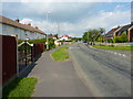
Brookhouse Lane becomes The Avenue
Heading east towards the older part of Featherstone village.
Image: © Richard Law
Taken: 18 Jun 2014
0.13 miles
2
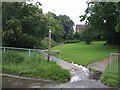
Footpath from Featherstone Hall Farm
Green space left among the new housing estate on the edge of the village.
Image: © John M
Taken: 22 Jul 2007
0.14 miles
3
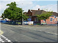
Whitgreave Primary School
The village primary for Featherstone, which would originally have served the children of miners at the Hilton Main colliery.
Image: © Richard Law
Taken: 18 Jun 2014
0.15 miles
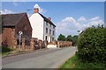
4
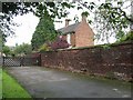
Featherstone Hall Farm
Traditional farmhouse on the edge of the expanded village.
Image: © John M
Taken: 22 Jul 2007
0.17 miles
5

Whitgreave Primary School
Featherstone was the mining village for the nearby Hilton Main Colliery. The shaft was sunk in the interwar period. The pit closed in the late 1960s. The school has seen a new influx as housing estates were built around the village. A new school would be required if the latest proposals for a further 1000 homes are approved.
Image: © John M
Taken: 22 Jul 2007
0.18 miles
6
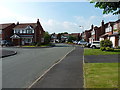
Campion Drive, Featherstone
This particular housing estate has a thoroughly floral theme to it - Campion, Cornflower, Teasel, Primrose, Harebell, Thistledown & Bellflower all feature in the road names. Another nearby takes the names of waterbirds, with Widgeon, Turnstone, Sanderling, Snipe & Woodcock used.
Image: © Richard Law
Taken: 18 Jun 2014
0.21 miles
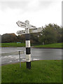
9
Featherstone Lane Sign
The view from the Finger Post down New Road.
Image: © Gordon Griffiths
Taken: 31 Aug 2012
0.25 miles