IMAGES TAKEN NEAR TO
Oak Tree Caravan Park, New Road, WOLVERHAMPTON, WV10 7NT
Introduction
This page details the photographs taken nearby to Oak Tree Caravan Park, New Road, WV10 7NT by members of the Geograph project.
The Geograph project started in 2005 with the aim of publishing, organising and preserving representative images for every square kilometre of Great Britain, Ireland and the Isle of Man.

There are currently over 7.5m images from over14,400 individuals and you can help contribute to the project by visiting https://www.geograph.org.uk
Image Map
Images are licensed for reuse under creativecommons.org/licenses/by-sa/2.0
Notes
- Clicking on the map will re-center to the selected point.
- The higher the marker number, the further away the image location is from the centre of the postcode.
Image Listing (2 Images Found)
Images are licensed for reuse under creativecommons.org/licenses/by-sa/2.0
Image
Details
Distance
1
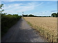
Up the track to Far Laches Farm
One part of a bridleway network that runs between Slade Heath, Latherford and Shareshill.
Image: © Richard Law
Taken: 21 Jul 2014
0.08 miles
2
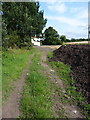
Far Laches Farm
A glimpse of some of the farm building from the bridleway that leads west and then northwest to Upper Laches.
Image: © Richard Law
Taken: 21 Jul 2014
0.16 miles