IMAGES TAKEN NEAR TO
Henley Road, WOLVERHAMPTON, WV10 6UY
Introduction
This page details the photographs taken nearby to Henley Road, WV10 6UY by members of the Geograph project.
The Geograph project started in 2005 with the aim of publishing, organising and preserving representative images for every square kilometre of Great Britain, Ireland and the Isle of Man.

There are currently over 7.5m images from over14,400 individuals and you can help contribute to the project by visiting https://www.geograph.org.uk
Image Map
Images are licensed for reuse under creativecommons.org/licenses/by-sa/2.0
Notes
- Clicking on the map will re-center to the selected point.
- The higher the marker number, the further away the image location is from the centre of the postcode.
Image Listing (27 Images Found)
Images are licensed for reuse under creativecommons.org/licenses/by-sa/2.0
Image
Details
Distance
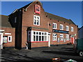
1

Rakegate Methodist Church, Oxley
Methodist Church on Renton Road in Oxley
Image: © Richard Law
Taken: 6 May 2011
0.15 miles
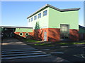
2
The Hop Pole, Oxley
Formerly The Oxley Moor Hotel
Image: © Alex McGregor
Taken: 20 Oct 2010
0.18 miles
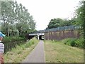
4
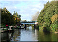
Staffordshire and Worcestershire Canal near Autherley Junction
Looking northwards, the bridge carries Blaydon Road.
Image: © Roger D Kidd
Taken: 16 Oct 2008
0.21 miles
5
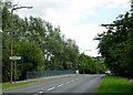
Blaydon Road at Pendeford, Wolverhampton
Looking towards Oxley. The road crosses the Staffordshire and Worcestershire Canal here.
Image: © Roger D Kidd
Taken: 11 Aug 2013
0.21 miles
6
Blaydon Road
The view of the road bridge over the Staffordshire and Worcestershire Canal at Pendeford.
Image: © Gordon Griffiths
Taken: 9 Jun 2020
0.22 miles
7
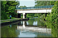
Blaydon Road Bridge near Pendeford in Wolverhampton
Blaydon Road Bridge is No 66 across the Staffordshire and Worcestershire Canal north of Autherley Junction. Housing nearby was developed in the 1950s or 1960s, so presumably the bridge dates from a similar time, but is incorporated in the current numbering sequence.
Image: © Roger Kidd
Taken: 26 Jun 2013
0.22 miles
8
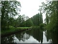
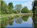
Staffs & Worcs canal, Pendeford
On the north-west edge of Wolverhampton.
Image: © Christine Johnstone
Taken: 11 May 2022
0.22 miles
9
Blaydon Road Scene
The view from the road bridge over the Staffordshire and Worcestershire Canal at Pendeford.
Image: © Gordon Griffiths
Taken: 25 Feb 2022
0.22 miles
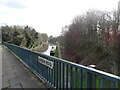
10
Staffordshire and Worcestershire Canal near Pendeford in Wolverhampton
Looking north from near Blaydon Road Bridge, No 66. Sustrans Route 81 passes along the towpath.
Open parkland and housing estates to the left were developed on the former Wolverhampton Municipal Airport.
Image: © Roger Kidd
Taken: 14 May 2016
0.22 miles