IMAGES TAKEN NEAR TO
Patshull Avenue, WOLVERHAMPTON, WV10 6RL
Introduction
This page details the photographs taken nearby to Patshull Avenue, WV10 6RL by members of the Geograph project.
The Geograph project started in 2005 with the aim of publishing, organising and preserving representative images for every square kilometre of Great Britain, Ireland and the Isle of Man.

There are currently over 7.5m images from over14,400 individuals and you can help contribute to the project by visiting https://www.geograph.org.uk
Image Map
Images are licensed for reuse under creativecommons.org/licenses/by-sa/2.0
Notes
- Clicking on the map will re-center to the selected point.
- The higher the marker number, the further away the image location is from the centre of the postcode.
Image Listing (101 Images Found)
Images are licensed for reuse under creativecommons.org/licenses/by-sa/2.0
Image
Details
Distance
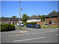
1
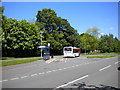
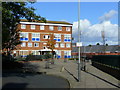
Bus turning circle, Wobaston
This turning circle, on Patshull Avenue, was constructed to allow buses serving this estate to turn; the buses approached from the south, so the turning circle was shaped accordingly. However, the only bus route that terminates here now, the 6 from Wolverhampton city centre via Whitmore Reans and Pendeford (one of which is visible in this picture), arrives from the north, and so the middle part of the turning circle (right) has been reshaped somewhat to enable the buses to enter it. The park on the left is bounded at its far end by the Staffordshire & Worcestershire Canal.
Image: © Richard Vince
Taken: 4 Jun 2013
0.02 miles
2
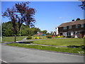
North end of Brinsford Road, Wobaston
At its north end, Brinsford Road (foreground) widens out to provide a pleasant patch of grass at its junction with Patshull Avenue.
Image: © Richard Vince
Taken: 4 Jun 2013
0.04 miles
3
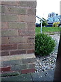
OS benchmark - Fordhouses, 42 Patshull Avenue
An OS cutmark on the side wall of no 42 Patshull Ave; originally levelled at 112.157m above Ordnance Datum Newlyn.
Image: © Richard Law
Taken: 1 Mar 2016
0.06 miles
4
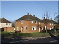
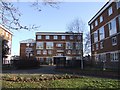
Council Housing - Patshull Avenue
Typical early 1950s council property on a corner plot. At this estate and its contemporary at Underhill no fencing was provided on the roadside boundary. This is unlike the prewar estates which have low concrete block walls.
Image: © John M
Taken: 9 Jan 2011
0.07 miles
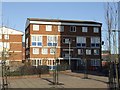
5
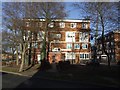
Council Housing - Shearwater Court
When completed in 1964 the four storey block had a flat roof.
Image: © John M
Taken: 9 Jan 2011
0.07 miles
6
Low-rise flats, Chetton Green
Near Fordhouses on the northern outskirts of Wolverhampton.
Image: © Jonathan Billinger
Taken: 21 Oct 2008
0.07 miles
7
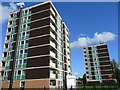
High-rise housing, Chetton Green
Near Fordhouses on the northern outskirts of Wolverhampton.
Image: © Jonathan Billinger
Taken: 21 Oct 2008
0.08 miles
8
Council Housing - Swallow Court
1964 built block on the Chetton Green Estate.
Image: © John M
Taken: 9 Jan 2011
0.08 miles
9
Patshull Grove, Wobaston
A short cul de sac off Patshull Avenue.
Image: © Richard Vince
Taken: 4 Jun 2013
0.08 miles
10
Council Housing - Starling Court
1964 block on the Chetton Green Estate falls in the shadow of one of the larger towerblocks.
Image: © John M
Taken: 9 Jan 2011
0.08 miles