IMAGES TAKEN NEAR TO
Greenfield Lane, WOLVERHAMPTON, WV10 6NY
Introduction
This page details the photographs taken nearby to Greenfield Lane, WV10 6NY by members of the Geograph project.
The Geograph project started in 2005 with the aim of publishing, organising and preserving representative images for every square kilometre of Great Britain, Ireland and the Isle of Man.

There are currently over 7.5m images from over14,400 individuals and you can help contribute to the project by visiting https://www.geograph.org.uk
Image Map
Images are licensed for reuse under creativecommons.org/licenses/by-sa/2.0
Notes
- Clicking on the map will re-center to the selected point.
- The higher the marker number, the further away the image location is from the centre of the postcode.
Image Listing (19 Images Found)
Images are licensed for reuse under creativecommons.org/licenses/by-sa/2.0
Image
Details
Distance
1
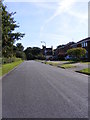
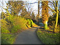
Greenfield Lane
The scene in Bushbury on the northern edge of Wolverhampton.
Image: © Gordon Griffiths
Taken: 12 Sep 2009
0.02 miles
2
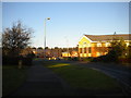
Brabourne Avenue, Fordhouses
Part of a business park off the A449 on the northern edge of Wolverhampton, close to junction 2 of the M54.
Image: © Richard Vince
Taken: 28 Dec 2016
0.05 miles
3
Broadlands, Fordhouses
Part of a business park off the A449 on the northern edge of Wolverhampton, close to junction 2 of the M54.
Image: © Richard Vince
Taken: 28 Dec 2016
0.09 miles
4
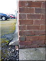
OS benchmark - Fordhouses, Springfield Court
An OS cutmark on garages at the side of Springfield Court flats; originally levelled at 113.337m above Ordnance Datum Newlyn.
Image: © Richard Law
Taken: 10 Mar 2016
0.09 miles
5
Path to Greenfield Lane, Fordhouses
Providing direct pedestrian access from Stafford Road.
Image: © Richard Vince
Taken: 28 Dec 2016
0.11 miles
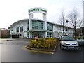
6
Bushbury, Moseley Park
Pub/restaurant on Wolverhampton Business Park, next to Image Spacious and modern, with back bar and eating/drinking areas on three sides; background music, games machines, garden. Cask ales on offer at my visit: Banks's Bitter, Wychwood Hobgoblin. https://www.tabletable.co.uk/pub-restaurants/West-Midlands/Moseley-Park-Wolverhampton.html
Image: © Mike Faherty
Taken: 23 Dec 2014
0.11 miles
7
Bushbury, Premier Inn
On Wolverhampton Business Park, with neighbouring pub/restaurant Image
Image: © Mike Faherty
Taken: 23 Dec 2014
0.12 miles
8
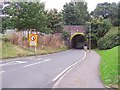
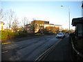
Greenfield Lane, Wolverhampton
Typical of most of the narrow and low headroom bridges under the Wolverhampton to Stafford line. These catch out the occasional high vehicles and can sometimes flood in heavy rainfall.
Image: © Adrian Bailey
Taken: 11 Oct 2005
0.13 miles
9
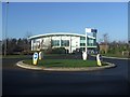
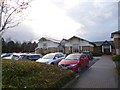
Health Club on the Broadlands Development
Popular sports centre on this business park development adjacent to the M54 Junction 2.
Image: © John M
Taken: 3 Feb 2007
0.15 miles
10
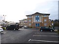
Bushbury, Nuffield Health
Fitness and well-being on offer at Wolverhampton Business Park: http://www.nuffieldhealth.com/gyms/wolverhampton
Image: © Mike Faherty
Taken: 23 Dec 2014
0.15 miles