IMAGES TAKEN NEAR TO
Mill Green, WOLVERHAMPTON, WV10 6LY
Introduction
This page details the photographs taken nearby to Mill Green, WV10 6LY by members of the Geograph project.
The Geograph project started in 2005 with the aim of publishing, organising and preserving representative images for every square kilometre of Great Britain, Ireland and the Isle of Man.

There are currently over 7.5m images from over14,400 individuals and you can help contribute to the project by visiting https://www.geograph.org.uk
Image Map
Images are licensed for reuse under creativecommons.org/licenses/by-sa/2.0
Notes
- Clicking on the map will re-center to the selected point.
- The higher the marker number, the further away the image location is from the centre of the postcode.
Image Listing (29 Images Found)
Images are licensed for reuse under creativecommons.org/licenses/by-sa/2.0
Image
Details
Distance
4
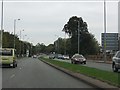
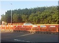
Sweeping curves on Stafford Road
The A449 has almost shed urban trappings and begins to look like the important trunk road it was before the M6 was constructed.
Image: © J Whatley
Taken: 6 Sep 2010
0.09 miles
5
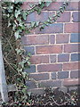
OS benchmark - Fordhouses, bridge on Stafford Road
An OS cutmark on the parapet of a small bridge on the west side of the dual carriageway; originally levelled at 109.951m above Ordnance Datum Newlyn.
Image: © Richard Law
Taken: 1 Mar 2016
0.10 miles
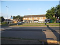
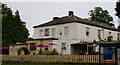
6
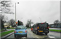
Traffic lights on the way into Wolverhampton
This is the junction of Stafford Road with Springfield Lane and the Moreton Arms can be seen ahead on the left.
Image: © Bill Boaden
Taken: 2 Jan 2016
0.10 miles
7
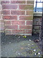
OS benchmark - Fordhouses, outside factory on Stafford Road
An OS cutmark on the roadside wall outside the entrance to the UTC Aerospace buildings on the Stafford Road; originally levelled at 112.032m above Ordnance Datum Newlyn.
Image: © Richard Law
Taken: 1 Mar 2016
0.11 miles
8
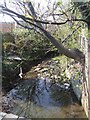
Waterhead Brook downstream of Stafford Road
Emerging from a culvert beneath the Stafford Road the brook runs between factories towards the i54 development at Wobaston. The brook seems to attract rubbish.
Image: © John M
Taken: 17 Apr 2010
0.11 miles
9
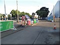
Petrol station on Stafford Road, Fordhouses
Image: © David Howard
Taken: 3 Jun 2018
0.12 miles