IMAGES TAKEN NEAR TO
Winchester Road, WOLVERHAMPTON, WV10 6EZ
Introduction
This page details the photographs taken nearby to Winchester Road, WV10 6EZ by members of the Geograph project.
The Geograph project started in 2005 with the aim of publishing, organising and preserving representative images for every square kilometre of Great Britain, Ireland and the Isle of Man.

There are currently over 7.5m images from over14,400 individuals and you can help contribute to the project by visiting https://www.geograph.org.uk
Image Map
Images are licensed for reuse under creativecommons.org/licenses/by-sa/2.0
Notes
- Clicking on the map will re-center to the selected point.
- The higher the marker number, the further away the image location is from the centre of the postcode.
Image Listing (54 Images Found)
Images are licensed for reuse under creativecommons.org/licenses/by-sa/2.0
Image
Details
Distance
1
Factory in Fordhouses
This is typical of the type of factory buildings on the outskirts of Wolverhampton.
Image: © Angella Streluk
Taken: 30 Jul 2005
0.06 miles
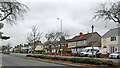
2
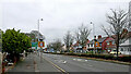
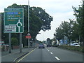
Stafford Road approaching the Vine Island in Wolverhampton
Stafford Road is the A449, leading north to Penkridge and Stafford. In this view the road is approaching the Vine Island (190 metres).
Image: © Roger Kidd
Taken: 30 Nov 2022
0.08 miles
3
Stafford Road near Fordhouses in Wolverhampton
Stafford Road is the A449, leading north to Penkridge and Stafford. In this view the road is approaching the Vine Island (200 metres).
Image: © Roger Kidd
Taken: 30 Nov 2022
0.08 miles
4
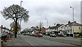
Stafford Road near Bushbury in Wolverhampton
Stafford Road is the A449, leading north to Penkridge and Stafford.
Image: © Roger Kidd
Taken: 30 Nov 2022
0.08 miles
6
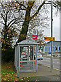
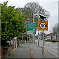
Bus shelter by Stafford Road in Wolverhampton
Stafford Road is the A449, leading north to Penkridge and Stafford. In this view the road is approaching the Vine Island (125 metres). Fordhouses Methodist Church is off to the left (access from Winchester Road).
Currently the 878 bus route goes to Stafford twice a day (11:11 and 12:11), via several villages. A few other buses just serve some of the villages. Route 877 goes to Stafford twice a day (10:11 and 13:11) via a different set of villages.
Image: © Roger Kidd
Taken: 30 Nov 2022
0.09 miles
7
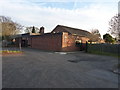
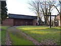
Fordhouses Methodist Church from the rear
Image: © Richard Law
Taken: 31 Jan 2011
0.09 miles
8
Stafford Road approaching the Vine Island in Wolverhampton
Stafford Road is the A449, leading north to Penkridge and Stafford. In this view the road is approaching the Vine Island (150 metres). Fordhouses Methodist Church is off to the left (access from Winchester Road).
Image: © Roger Kidd
Taken: 30 Nov 2022
0.09 miles
9
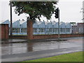
Fordhouses Methodist Church
The frontage of the church, facing onto the Stafford Road dual carriageway. God, these days, apparently needs to be accessed through steel security railings. No matter that they're each disguised with a cross, it's still a sad indictment on our times.
Image: © Richard Law
Taken: 31 Jan 2011
0.10 miles
10
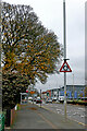
Stafford Road near Bushbury in Wolverhampton
Stafford Road is the A449, leading north to Penkridge and Stafford.
Image: © Roger Kidd
Taken: 30 Nov 2022
0.10 miles