IMAGES TAKEN NEAR TO
Barrington Close, WOLVERHAMPTON, WV10 6AZ
Introduction
This page details the photographs taken nearby to Barrington Close, WV10 6AZ by members of the Geograph project.
The Geograph project started in 2005 with the aim of publishing, organising and preserving representative images for every square kilometre of Great Britain, Ireland and the Isle of Man.

There are currently over 7.5m images from over14,400 individuals and you can help contribute to the project by visiting https://www.geograph.org.uk
Image Map
Images are licensed for reuse under creativecommons.org/licenses/by-sa/2.0
Notes
- Clicking on the map will re-center to the selected point.
- The higher the marker number, the further away the image location is from the centre of the postcode.
Image Listing (112 Images Found)
Images are licensed for reuse under creativecommons.org/licenses/by-sa/2.0
Image
Details
Distance
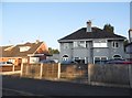
1
Barrington Close, Oxley
A residential cul de sac off Stafford Road.
Image: © Richard Vince
Taken: 28 Dec 2016
0.05 miles
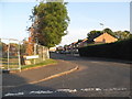
3
Church Road near Oxley in Wolverhampton
Looking west-south-west towards the A449 Stafford Road. Marklin Avenue is off to the left.
Image: © Roger Kidd
Taken: 29 Nov 2021
0.06 miles
4
Stafford Road, Oxley
Between Oxley Moor Road and the Three Tuns roundabout.
Image: © Richard Vince
Taken: 28 Dec 2016
0.07 miles
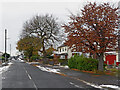
5
Church Road and Marklin Avenue near Oxley, Wolverhampton
Looking west-south-west towards the A449 Stafford Road.
Image: © Roger Kidd
Taken: 29 Nov 2021
0.07 miles
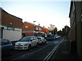
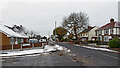
7
Church Road near Oxley in Wolverhampton
Looking east-north-east from near the junction with Stafford Road (the A449). Lymer Road is off to the right.
Image: © Roger Kidd
Taken: 29 Nov 2021
0.08 miles
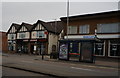
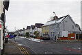
9
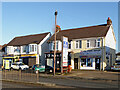
Shops near Bushbury in Wolverhampton
It appears that these two semi-detached shop premises by the A449 Stafford Road still use the first floors as residential flats. I notice that the far one has been modernised and chimneys removed. It's odd that the phone repair shop has no upstairs bay window.
Rennsport MOT and car repair centre is behind the shops, off to the right. Highly recommended.
The shops here (apart from the off-licence!) are classified "non-essential", so closed by law during the second full coronavirus Covid-19 lockdown.
Image]
Image: © Roger Kidd
Taken: 26 Nov 2020
0.08 miles
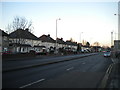
10

Church Road near Oxley in Wolverhampton
Looking west-south-west towards the A449 Stafford Road.
The snow is a remnant of the 6-8cm fall dumped by Storm Arwen three days earlier.
Image: © Roger Kidd
Taken: 29 Nov 2021
0.09 miles