IMAGES TAKEN NEAR TO
Thorneycroft Lane, WOLVERHAMPTON, WV10 0NF
Introduction
This page details the photographs taken nearby to Thorneycroft Lane, WV10 0NF by members of the Geograph project.
The Geograph project started in 2005 with the aim of publishing, organising and preserving representative images for every square kilometre of Great Britain, Ireland and the Isle of Man.

There are currently over 7.5m images from over14,400 individuals and you can help contribute to the project by visiting https://www.geograph.org.uk
Image Map
Images are licensed for reuse under creativecommons.org/licenses/by-sa/2.0
Notes
- Clicking on the map will re-center to the selected point.
- The higher the marker number, the further away the image location is from the centre of the postcode.
Image Listing (44 Images Found)
Images are licensed for reuse under creativecommons.org/licenses/by-sa/2.0
Image
Details
Distance
1
Heath Town Methodist Church
This is tucked away behind the hospital site, in Wimborne Road.
Image: © Richard Law
Taken: 9 Apr 2010
0.04 miles
2
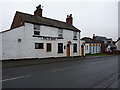
The Bird In Hand
A free house on Thorneycroft Lane, New Cross area.
Image: © Richard Law
Taken: 5 Feb 2015
0.05 miles
3
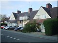
Fallings Park Garden Village - Thorneycroft Lane
Houses built for the Model Housing Exhibition of 1908 by M Crickner featuring a modified design of his first prize-winning homes from Letchworth Garden Suburb.
Image: © John M
Taken: 15 Oct 2011
0.07 miles
4
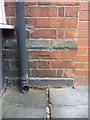
OS benchmark - New Cross, 173 Bushbury Road
An OS cutmark on the wall of no 173 Bushbury Rd, at the junction with Victoria Rd; originally levelled at 142.643m above Ordnance Datum Newlyn.
Image: © Richard Law
Taken: 5 Feb 2015
0.11 miles
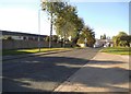
5
The Avenue
Little suggests this is a road apart from an extra set of traffic lights at the junction with Victoria Road and Bushbury Lane. It must come as quite a surprise to other drivers when a car appears out of here. This is a relic of the 1908 Housing Exhibition on the Fallings Park Garden Village. At the end of the road are two pairs of semi-detached properties.
Image: © John M
Taken: 10 Sep 2011
0.11 miles
6
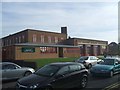
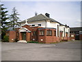
Fallings Park Community Fire Station
Situated at a busy intersection the fire station is handily placed to serve the North of Wolverhampton. The low level extension is a recent addition.
Image: © John M
Taken: 4 Feb 2007
0.12 miles
7
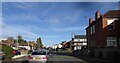
Victoria Road
The view in Fallings Park, Wolverhampton.
Image: © Gordon Griffiths
Taken: 28 Oct 2022
0.12 miles
8
Hospital Entrance
The view down the road towards Prestwood Road from New Cross Hospital in Wolverhampton.
Image: © Gordon Griffiths
Taken: 1 Oct 2015
0.14 miles
9
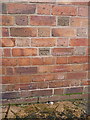
OS benchmark - Newbolds, 207 Bushbury Road
An OS cutmark on the projecting frontage of no 207 Bushbury Road; originally levelled at 142.982m above Ordnance Datum Newlyn.
Image: © Richard Law
Taken: 5 Feb 2015
0.14 miles
10

Parting of the ways
The road sign here marks where the turnpike into Wolverhampton was built taking a more direct route into town. The sign from pre 1902 is locally listed and was supplied by W H Smith of Whitchurch.
Image: © John M
Taken: 25 Dec 2008
0.15 miles