IMAGES TAKEN NEAR TO
Wednesfield Road, WOLVERHAMPTON, WV10 0EH
Introduction
This page details the photographs taken nearby to Wednesfield Road, WV10 0EH by members of the Geograph project.
The Geograph project started in 2005 with the aim of publishing, organising and preserving representative images for every square kilometre of Great Britain, Ireland and the Isle of Man.

There are currently over 7.5m images from over14,400 individuals and you can help contribute to the project by visiting https://www.geograph.org.uk
Image Map
Images are licensed for reuse under creativecommons.org/licenses/by-sa/2.0
Notes
- Clicking on the map will re-center to the selected point.
- The higher the marker number, the further away the image location is from the centre of the postcode.
Image Listing (77 Images Found)
Images are licensed for reuse under creativecommons.org/licenses/by-sa/2.0
Image
Details
Distance
1
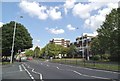
Wednesfield Road Crossing
The view of the A4124 from Burton Road in Springfield, Wolverhampton.
Image: © Gordon Griffiths
Taken: 20 Jun 2014
0.02 miles
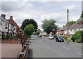
2
Burton Road, Springfield
Residential street leading off Wednesfield Road to the east of Wolverhampton city centre.
Image: © Stephen McKay
Taken: 16 Jan 2018
0.03 miles
3
Wednesfield Road Scene
The view down the A4124 in Wolverhampton.
Image: © Gordon Griffiths
Taken: 27 Apr 2022
0.03 miles
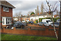
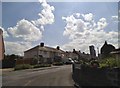
4
Houses on Hemmings Close, Springfield
The bungalows on the right face into Hemmings Close here, and their rears are presented to the much busier and noisier Wednesfield Road.
Image: © Richard Law
Taken: 4 Feb 2025
0.05 miles
5
Springfield Road in Wolverhampton
Looking north-west from the junction with the A4124 Wednesfield Road.
Image: © Roger D Kidd
Taken: 4 Jul 2017
0.05 miles
6
Burton Crescent Corner
The view from Burton Road in Springfield, Wolverhampton.
Image: © Gordon Griffiths
Taken: 20 Jun 2014
0.06 miles
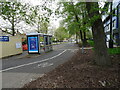
7
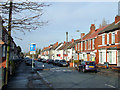
Springfield Road, Wolverhampton
Early 20th century housing on a road linking the Brownhills (A4124) and Cannock (A460) roads. The usual tampering has been done to the road and its width to (supposedly) make the roads safer for everybody.
Image: © Roger D Kidd
Taken: 17 Dec 2008
0.07 miles
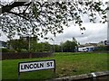
8
Lincoln Street
The view off Wednesfield Road in Wolverhampton.
Image: © Gordon Griffiths
Taken: 27 Apr 2022
0.08 miles
9
Lincoln Street View
The view near the Wednesfield Road in Wolverhampton.
Image: © Gordon Griffiths
Taken: 27 Apr 2022
0.09 miles
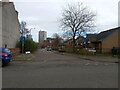
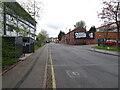
10
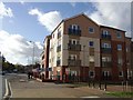
Private Housing - Wednesfield Road
The new housing development in the heart of the 1960s Heath Town Estate on the site of the former Chubb safe factory. A large number of the properties are for sale or rent.
Image: © John M
Taken: 13 Nov 2010
0.10 miles