IMAGES TAKEN NEAR TO
Church View, WALSALL, WS9 9QX
Introduction
This page details the photographs taken nearby to Church View, WS9 9QX by members of the Geograph project.
The Geograph project started in 2005 with the aim of publishing, organising and preserving representative images for every square kilometre of Great Britain, Ireland and the Isle of Man.

There are currently over 7.5m images from over14,400 individuals and you can help contribute to the project by visiting https://www.geograph.org.uk
Image Map
Images are licensed for reuse under creativecommons.org/licenses/by-sa/2.0
Notes
- Clicking on the map will re-center to the selected point.
- The higher the marker number, the further away the image location is from the centre of the postcode.
Image Listing (31 Images Found)
Images are licensed for reuse under creativecommons.org/licenses/by-sa/2.0
Image
Details
Distance
1
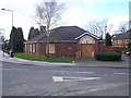
Walsall Wood Library
Was originally Walsall Wood Neighbourhood Office but is soon to become the new home for Walsall Wood's library.
Image: © Adrian Rothery
Taken: 6 Mar 2007
0.02 miles
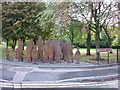
4
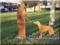
'People' of Walsall Wood
New public sculpture in the former mining village. Each figure has a comment even Scruff the dog.
My favourites are
'Its only when you step outside the box, you realise what has changed. Buildings have been built or been knocked down, things like that, but when you are within that community; you change with it. You move with it.'
'Our neighbour used to keep pigs. 'Er only ad one at a time. They was always called Billy. We always cried when Billy the Pig was done in but we always ate im.'
My mother's family were miners in the Coppice Pit and other pits in the Brownhills area.
Image: © John M
Taken: 28 Jan 2011
0.05 miles
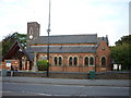
5
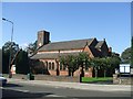
St Johns Church
The church on the Walsall to Lichfield road was consecrated in 1837 and the chancel, vestry and aisles were added in 1886. In the last few years a new porch and rooms have been added.
Image: © John M
Taken: 21 Oct 2006
0.05 miles
6
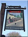
Pub sign at the 'Boatmens Rest'
The pub backs on to the Daw End Branch Canal. The canal transported millions of tons of coal from the collieries of Walsall Wood and Brownhills to the industries of Birmingham and the Black Country. The last pit closed in 1964. Originally known as the Red Lion.
Image: © John M
Taken: 28 Jan 2011
0.07 miles
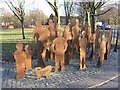
7
The Miner & his Whippet
New public artwork in the former mining village.
The image is taken from a stained glass window in nearby St Johns Church.
'Walsall Wood Colliery first drew coal in 1874 stretching from Brownhills to Vigo Corner. Beneath the ground on which you now stand thousands of men mined coal for a hungry British industry. At its height it drew 7000 tonnes per week at great cost to human life but from its industry this town grew. After 90 years the seams were exhausted and in 1964 the pit closed forever'
My great grandfather and his brother were killed in the pit.
Image: © John M
Taken: 28 Jan 2011
0.08 miles
9
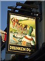
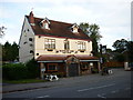
Pub sign for the Drunken Duck
Public house in the High Street formerly known as the Hawthorn .
Image: © John M
Taken: 28 Jan 2011
0.10 miles
10
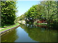
Daw End Branch, Wyrley & Essington Canal, Walsall Wood
The back gardens on the right [east] belong to houses in St John's Close.
Image: © Christine Johnstone
Taken: 6 May 2018
0.11 miles