IMAGES TAKEN NEAR TO
The Green, WALSALL, WS9 8NH
Introduction
This page details the photographs taken nearby to The Green, WS9 8NH by members of the Geograph project.
The Geograph project started in 2005 with the aim of publishing, organising and preserving representative images for every square kilometre of Great Britain, Ireland and the Isle of Man.

There are currently over 7.5m images from over14,400 individuals and you can help contribute to the project by visiting https://www.geograph.org.uk
Image Map
Images are licensed for reuse under creativecommons.org/licenses/by-sa/2.0
Notes
- Clicking on the map will re-center to the selected point.
- The higher the marker number, the further away the image location is from the centre of the postcode.
Image Listing (24 Images Found)
Images are licensed for reuse under creativecommons.org/licenses/by-sa/2.0
Image
Details
Distance
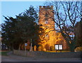
1
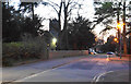
The Green at dusk
The profile of St Mary's Church is in the centre.
Image: © Bill Boaden
Taken: 19 Apr 2018
0.01 miles
4
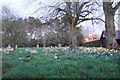
Daffodils in the graveyard
Aldridge churchyard extension viewed at dusk.
Image: © Bill Boaden
Taken: 19 Apr 2018
0.03 miles
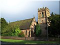
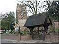
5
St Mary's Church, Aldridge
The parish church floodlit in the evening.
Image: © Bill Boaden
Taken: 19 Apr 2018
0.05 miles
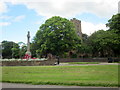
7
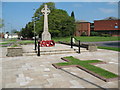
Aldridge War Memorial
The Green, Aldridge.
Image: © Adrian Rothery
Taken: 13 May 2008
0.07 miles
9
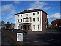
Aldridge Manor House
Little Aston Road, Aldridge.
Image: © Adrian Rothery
Taken: 6 Mar 2007
0.11 miles
10
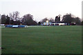
Aldridge Cricket Club
Daylight is fading and all activity is appropriately in the clubhouse.
Image: © Bill Boaden
Taken: 19 Apr 2018
0.11 miles