IMAGES TAKEN NEAR TO
Penk Drive, BURNTWOOD, WS7 9JT
Introduction
This page details the photographs taken nearby to Penk Drive, WS7 9JT by members of the Geograph project.
The Geograph project started in 2005 with the aim of publishing, organising and preserving representative images for every square kilometre of Great Britain, Ireland and the Isle of Man.

There are currently over 7.5m images from over14,400 individuals and you can help contribute to the project by visiting https://www.geograph.org.uk
Image Map
Images are licensed for reuse under creativecommons.org/licenses/by-sa/2.0
Notes
- Clicking on the map will re-center to the selected point.
- The higher the marker number, the further away the image location is from the centre of the postcode.
Image Listing (14 Images Found)
Images are licensed for reuse under creativecommons.org/licenses/by-sa/2.0
Image
Details
Distance
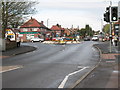
1
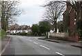
Junction of Rugeley Road and Church Road
Image: © Adrian Rothery
Taken: 10 Apr 2009
0.14 miles
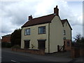
5
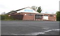
Burntwood Memorial Community Association
Rugeley Road, Burntwood.
Image: © Adrian Rothery
Taken: 10 Apr 2009
0.19 miles
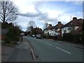
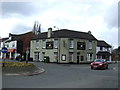
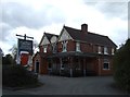
6
White Swan PH, Burntwood
At the junction of A5190 Cannock Road and Rugeley Road.
Image: © Adrian Rothery
Taken: 10 Apr 2009
0.19 miles
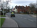
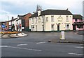
10
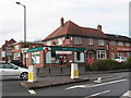
Burntwood Post Office
At the junction of A5190 Cannock Road and Chase Road.
Image: © Adrian Rothery
Taken: 10 Apr 2009
0.22 miles