IMAGES TAKEN NEAR TO
The Hollies, BURNTWOOD, WS7 9EY
Introduction
This page details the photographs taken nearby to The Hollies, WS7 9EY by members of the Geograph project.
The Geograph project started in 2005 with the aim of publishing, organising and preserving representative images for every square kilometre of Great Britain, Ireland and the Isle of Man.

There are currently over 7.5m images from over14,400 individuals and you can help contribute to the project by visiting https://www.geograph.org.uk
Image Map
Images are licensed for reuse under creativecommons.org/licenses/by-sa/2.0
Notes
- Clicking on the map will re-center to the selected point.
- The higher the marker number, the further away the image location is from the centre of the postcode.
Image Listing (3 Images Found)
Images are licensed for reuse under creativecommons.org/licenses/by-sa/2.0
Image
Details
Distance
1
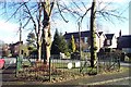
The Smallest Park in Britain
Prince's Park, Burntwood was opened in 1863 to commemorate the marriage of Prince Albert Edward, the Duke of Wales, to Princess Alexandra of Denmark. It is officially the smallest park in Great Britain. There is a bench inside where you can sit and watch the traffic!
Image: © Geoff Pick
Taken: 14 Feb 2006
0.12 miles
2

Junction of St Matthew's Road and Coulter Lane
Image: © Adrian Rothery
Taken: 10 Apr 2009
0.18 miles
3
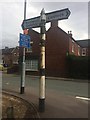
Old Direction Sign - Signpost by St Matthew's Road,
Pawn finial - 2 Worboys arms; by the UC road, in parish of Burntwood (Lichfield District), junction of Coulter Lane with St Matthew's Road.
To be surveyed
Milestone Society National ID: ST_SK0709A
Image: © Milestone Society
Taken: Unknown
0.18 miles