IMAGES TAKEN NEAR TO
WS7 8PD
Introduction
This page details the photographs taken nearby to WS7 8PD by members of the Geograph project.
The Geograph project started in 2005 with the aim of publishing, organising and preserving representative images for every square kilometre of Great Britain, Ireland and the Isle of Man.

There are currently over 7.5m images from over14,400 individuals and you can help contribute to the project by visiting https://www.geograph.org.uk
Image Map
Images are licensed for reuse under creativecommons.org/licenses/by-sa/2.0
Notes
- Clicking on the map will re-center to the selected point.
- The higher the marker number, the further away the image location is from the centre of the postcode.
Image Listing (6 Images Found)
Images are licensed for reuse under creativecommons.org/licenses/by-sa/2.0
Image
Details
Distance
4
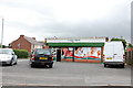
Convenience store at the junction of Rugeley and Chorley Roads
Image: © Basher Eyre
Taken: 16 Aug 2020
0.19 miles
5
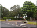
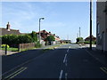
Looking from Rugeley Road into Coney Lodge View
Image: © Basher Eyre
Taken: 16 Aug 2020
0.23 miles
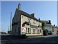
6
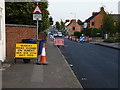
Roadworks in Chase Terrace
Having spotted (and read) the sign (twice, to make sure I wasn't imagining it) I fully intended to return on the 21nd of July to see what parallel universe the signwriter was occupying when he put paint to metal. Never had the chance, sadly. Maybe the roadworks over-ran, and went on until the 23th in the end?
Image: © Richard Law
Taken: 18 Jul 2013
0.23 miles