IMAGES TAKEN NEAR TO
Coppice Lane, BURNTWOOD, WS7 0JY
Introduction
This page details the photographs taken nearby to Coppice Lane, WS7 0JY by members of the Geograph project.
The Geograph project started in 2005 with the aim of publishing, organising and preserving representative images for every square kilometre of Great Britain, Ireland and the Isle of Man.

There are currently over 7.5m images from over14,400 individuals and you can help contribute to the project by visiting https://www.geograph.org.uk
Image Map
Images are licensed for reuse under creativecommons.org/licenses/by-sa/2.0
Notes
- Clicking on the map will re-center to the selected point.
- The higher the marker number, the further away the image location is from the centre of the postcode.
Image Listing (6 Images Found)
Images are licensed for reuse under creativecommons.org/licenses/by-sa/2.0
Image
Details
Distance
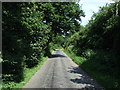
2
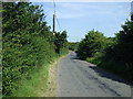
Coppice Lane heading east
Towards the A461.
Image: © JThomas
Taken: 11 Jul 2013
0.08 miles
3
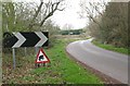
Caution, jumping amphibians
Frogs or toads? I don't suppose it makes any difference once they are squashed into your tyre treads.
The rarity of these signs requires that they be chained to something solid.
Image: © Adrian Rothery
Taken: 2 Apr 2009
0.13 miles
4
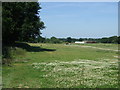
Former Route of The Lichfield And Hatherton Canal
Image: © Geoff Pick
Taken: 11 Sep 2009
0.19 miles
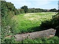
6
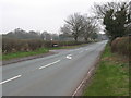
Junction of Walsall Road and Coppice Lane
Image: © Adrian Rothery
Taken: 2 Apr 2009
0.25 miles