IMAGES TAKEN NEAR TO
Lydford Road, WALSALL, WS3 3NT
Introduction
This page details the photographs taken nearby to Lydford Road, WS3 3NT by members of the Geograph project.
The Geograph project started in 2005 with the aim of publishing, organising and preserving representative images for every square kilometre of Great Britain, Ireland and the Isle of Man.

There are currently over 7.5m images from over14,400 individuals and you can help contribute to the project by visiting https://www.geograph.org.uk
Image Map
Images are licensed for reuse under creativecommons.org/licenses/by-sa/2.0
Notes
- Clicking on the map will re-center to the selected point.
- The higher the marker number, the further away the image location is from the centre of the postcode.
Image Listing (5 Images Found)
Images are licensed for reuse under creativecommons.org/licenses/by-sa/2.0
Image
Details
Distance
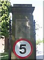
1
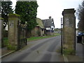
King George V Memorial Playing Fields, Bloxwich
The gates of King George V Memorial Playing Fields, Stafford Road, Bloxwich. The road through the gates is called William Wiggin Avenue in memory of the man who donated the land for these fields. https://thebloxwichtelegraph.com/history/bloxwich-parks-history/
Image: © Roger W Haworth
Taken: 19 Feb 2019
0.11 miles
2
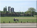
A quiet moment in the King George V Memorial Playing Fields
Marked by the heraldic panel at the entrance the fields were established by the King George’s Fields Foundation "to promote and to assist in the establishment throughout the United Kingdom of Great Britain and Northern Ireland of playing fields for the use and enjoyment of the people....'
The fields here have bowling greens, rugby and cricket pitches. There is another entrance near the flats at Sandhills.
Image: © John M
Taken: 22 May 2010
0.21 miles
3
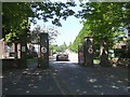
King George V Memorial Playing Fields
Marked by the heraldic panel at the entrance the fields were established by the King George’s Fields Foundation "to promote and to assist in the establishment throughout the United Kingdom of Great Britain and Northern Ireland of playing fields for the use and enjoyment of the people every such playing field to be styled 'King George’s Field' and to be distinguished by heraldic panels or other appropriate tablet medallion or inscription commemorative of His Late Majesty and of a design approved by the Administrative Council."
The heraldic panel on the left shows the lion and the panel on the right shows the unicorn. The panels were provided by the Foundation and their approval was required for the entrance.
Image: © John M
Taken: 22 May 2010
0.24 miles
4
Heraldic Panel - King George's Field
Marked by the heraldic panel at the entrance the fields were established by the King George’s Fields Foundation "to promote and to assist in the establishment throughout the United Kingdom of Great Britain and Northern Ireland of playing fields for the use and enjoyment of the people every such playing field to be styled 'King George’s Field' and to be distinguished by heraldic panels or other appropriate tablet medallion or inscription commemorative of His Late Majesty and of a design approved by the Administrative Council."
The heraldic panel on the left shows the lion and the panel on the right shows the unicorn. The panels were provided by the Foundation and their approval was required for the entrance.
Image: © John M
Taken: 22 May 2010
0.24 miles
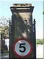
5
Heraldic panel - King George's Field
Marked by the heraldic panel at the entrance the fields were established by the King George’s Fields Foundation "to promote and to assist in the establishment throughout the United Kingdom of Great Britain and Northern Ireland of playing fields for the use and enjoyment of the people every such playing field to be styled 'King George’s Field' and to be distinguished by heraldic panels or other appropriate tablet medallion or inscription commemorative of His Late Majesty and of a design approved by the Administrative Council."
The heraldic panel on the left shows the lion and the panel on the right shows the unicorn. The panels were provided by the Foundation and their approval was required for the entrance.
Image: © John M
Taken: 22 May 2010
0.25 miles