IMAGES TAKEN NEAR TO
Deeley Street, WALSALL, WS3 2DJ
Introduction
This page details the photographs taken nearby to Deeley Street, WS3 2DJ by members of the Geograph project.
The Geograph project started in 2005 with the aim of publishing, organising and preserving representative images for every square kilometre of Great Britain, Ireland and the Isle of Man.

There are currently over 7.5m images from over14,400 individuals and you can help contribute to the project by visiting https://www.geograph.org.uk
Image Map
Images are licensed for reuse under creativecommons.org/licenses/by-sa/2.0
Notes
- Clicking on the map will re-center to the selected point.
- The higher the marker number, the further away the image location is from the centre of the postcode.
Image Listing (43 Images Found)
Images are licensed for reuse under creativecommons.org/licenses/by-sa/2.0
Image
Details
Distance
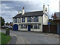
3
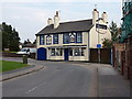
The Hatherton Arms
A free house on Reves Street in Bloxwich.
Image: © Richard Law
Taken: 5 Sep 2013
0.04 miles
4
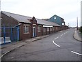
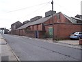
Chamberlin & Hill, Bloxwich Foundry
Reeves Street, Bloxwich.
Image: © Adrian Rothery
Taken: 20 Oct 2006
0.09 miles
6
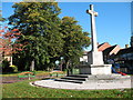
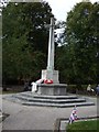
Bloxwich War Memorial
High Street, Bloxwich.
Image: © Adrian Rothery
Taken: 5 Oct 2007
0.10 miles
7
Chamberlin & Hill, Bloxwich Foundry
Reeves Street, Bloxwich.
Image: © Adrian Rothery
Taken: 20 Oct 2006
0.11 miles
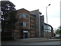
8
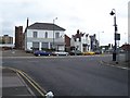
High Street, Bloxwich
The boarded-up ex TSB bank with Bloxwich fire station behind.
Image: © Adrian Rothery
Taken: 20 Oct 2006
0.11 miles