IMAGES TAKEN NEAR TO
Blakenall Lane, WALSALL, WS3 1HH
Introduction
This page details the photographs taken nearby to Blakenall Lane, WS3 1HH by members of the Geograph project.
The Geograph project started in 2005 with the aim of publishing, organising and preserving representative images for every square kilometre of Great Britain, Ireland and the Isle of Man.

There are currently over 7.5m images from over14,400 individuals and you can help contribute to the project by visiting https://www.geograph.org.uk
Image Map
Images are licensed for reuse under creativecommons.org/licenses/by-sa/2.0
Notes
- Clicking on the map will re-center to the selected point.
- The higher the marker number, the further away the image location is from the centre of the postcode.
Image Listing (23 Images Found)
Images are licensed for reuse under creativecommons.org/licenses/by-sa/2.0
Image
Details
Distance
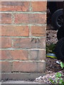
1
OS benchmark - Blakenall Heath, 88 Blakenall Lane
An OS cutmark on the front wall of the house; originally levelled, probably in 1957, at 154.832m above Ordnance Datum Newlyn.
Image: © Richard Law
Taken: 27 Sep 2016
0.03 miles
3
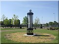
Davy Lamp - Leamore Park
Brownhills may have its miner but Leamore has a miner's lamp. The run down Blakenhall Estate has received a large injection of 'New Deal' investment to smarten up the area including this public artwork in the park. Leamore developed as a mining area in the 1850s with most shafts worked out by the turn of the century. The last colliery in the area at Walsall Wood closed in the 1960s.
The Davy Lamp designed by Sir Humphry Davy in 1815 was a major improvement in mine safety. The flame from an oil lamp is encased in wire gauze inside a glass cylinder. This reduces the risk of explosion through the use of open flames where flammable gases may be present. The colour of the flame provides an indication of the presence of gas.
Image: © John M
Taken: 22 May 2010
0.05 miles
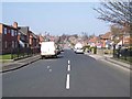
4
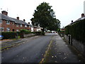
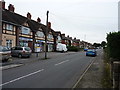
Hollemeadow Avenue, Blakenall Heath
Closely-packed inter-war housing developments in Blakenall Heath
Image: © Richard Law
Taken: 27 Sep 2016
0.08 miles
6
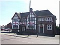
Preparing for World Cup 2010 at the New Inn - Blakenhall
The current New Inn replaced the old New Inn in 1938. It appears to have been extended at a later date to add a lounge and what is now a pool room.
Image: © John M
Taken: 22 May 2010
0.14 miles
7
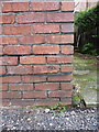
OS benchmark - Blakenall Heath, 15 Guild Avenue
An OS cutmark located on the front wall of a house on Guild Avenue; originally levelled, probably in 1957, at 159.673m above Ordnance Datum Newlyn.
Image: © Richard Law
Taken: 27 Sep 2016
0.15 miles
8
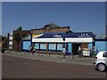
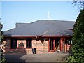
Nisa supermarket - Blakenhall
The building was originally built for the Walsall and District Cooperative Society in 1921 and is contemporary with the large council estates that were springing up around Blakenall Heath and Harden.
Image: © John M
Taken: 22 May 2010
0.15 miles
9
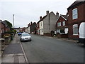
Foster Street, Blakenall Heath
A mixture of Victorian terracing and slightly more recent (inter- and post-war) housing development.
Image: © Richard Law
Taken: 27 Sep 2016
0.16 miles