IMAGES TAKEN NEAR TO
Oldhall Road, WALSALL, WS3 1FD
Introduction
This page details the photographs taken nearby to Oldhall Road, WS3 1FD by members of the Geograph project.
The Geograph project started in 2005 with the aim of publishing, organising and preserving representative images for every square kilometre of Great Britain, Ireland and the Isle of Man.

There are currently over 7.5m images from over14,400 individuals and you can help contribute to the project by visiting https://www.geograph.org.uk
Image Map
Images are licensed for reuse under creativecommons.org/licenses/by-sa/2.0
Notes
- Clicking on the map will re-center to the selected point.
- The higher the marker number, the further away the image location is from the centre of the postcode.
Image Listing (5 Images Found)
Images are licensed for reuse under creativecommons.org/licenses/by-sa/2.0
Image
Details
Distance
1
Goscote Hall Bridge - Wyrley & Essington Canal
Carries Slacky Lane over the Wyrley & Essington Canal.
Notice the overflow system in the foreground.
Image: © Adrian Rothery
Taken: 22 May 2007
0.09 miles
2
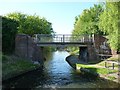
Goscote Hall Bridge, from the south
Carrying Slacky Lane over the Wyrley & Essington Canal.
Image: © Christine Johnstone
Taken: 6 May 2018
0.09 miles
3
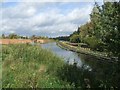
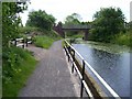
Landscaping to towpath at Goscote Valley
The land adjacent to the canal north of Goscote Hall Bridge on Slacky Lane has recently been landscaped and a low rail fence with timber blocks installed.
Image: © John M
Taken: 21 Oct 2006
0.10 miles
4
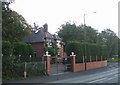
Top Lodge at Goscote Hospital
This lodge is adjacent to the former Goscote Hospital.
Image: © John M
Taken: 21 Oct 2006
0.11 miles
5
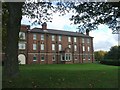
Goscote Hospital
This was originally an Isolation Hospital between 1929 and 1948, later used as a Rehabilitation Hospital before finally closing on 1st May 2006 despite local protests.
Image: © John M
Taken: 21 Oct 2006
0.17 miles