IMAGES TAKEN NEAR TO
Darlaston Road, WALSALL, WS2 9QT
Introduction
This page details the photographs taken nearby to Darlaston Road, WS2 9QT by members of the Geograph project.
The Geograph project started in 2005 with the aim of publishing, organising and preserving representative images for every square kilometre of Great Britain, Ireland and the Isle of Man.

There are currently over 7.5m images from over14,400 individuals and you can help contribute to the project by visiting https://www.geograph.org.uk
Image Map
Images are licensed for reuse under creativecommons.org/licenses/by-sa/2.0
Notes
- Clicking on the map will re-center to the selected point.
- The higher the marker number, the further away the image location is from the centre of the postcode.
Image Listing (40 Images Found)
Images are licensed for reuse under creativecommons.org/licenses/by-sa/2.0
Image
Details
Distance
1
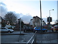
Walsall housing going, going - West Midlands
Demolition taking place as part of the programme to remodel the junction of Bescot Road, Darlaston Road, Old Pleck Road and Wednesbury Road in Walsall. Time taken 4.11 pm GMT (Greenwich Mean Time).
Image: © Martin Richard Phelan
Taken: 30 Jan 2015
0.06 miles
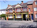
2
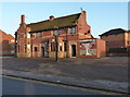
The Four Horseshoes, Wellington Street
By the look of it, the Four Horseshoes has closed, although maybe only recently. Three local lads who were talking on the carpark (just out of shot) might have known something of the history of the place, but since I was carrying a camera and a GPS, I decided against approaching them.
Image: © Richard Law
Taken: 9 Jan 2013
0.07 miles
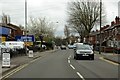
3
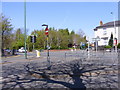
Old Pleck Road Junction
The junction with Darlaston Road.
Image: © Gordon Griffiths
Taken: 21 Apr 2009
0.08 miles
4
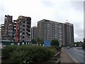
The changing face of Pleck
The towerblocks alongside the Walsall Ring Road are soon to be demolished to be replaced by a Bovis Homes development. This will change the view Image
Image: © John M
Taken: 15 May 2007
0.08 miles
5
Brown Lion
A Pub on Wednesbury Road, Pleck.
Image: © Gordon Griffiths
Taken: 21 Apr 2009
0.09 miles
7
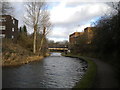
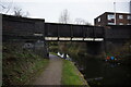
Walsall Canal, Pleck (3)
Approaching Woodwards Bridge, with a Gurdwara visible beyond it on the right.
Image: © Richard Vince
Taken: 1 Feb 2020
0.10 miles
8
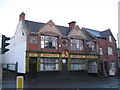
At the sign of the Brown Lion - Walsall, West Midlands
The history of the building dates from Victorian times but it has not been in use as a pub for some years now, having been divided into flats after its closure. I thought that the name was unique but there is another Brown Lion in Birmingham's Jewellery Quarter. The HBCo refers to the Highgate Brewery Company. Time taken 4.08 pm GMT (Greenwich Mean Time).
Image: © Martin Richard Phelan
Taken: 30 Jan 2015
0.10 miles
10
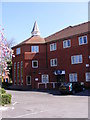
Pleck Methodist Church
The church on Old Pleck Road.
Image: © Gordon Griffiths
Taken: 21 Apr 2009
0.11 miles