IMAGES TAKEN NEAR TO
Wallows Lane, WALSALL, WS2 9BU
Introduction
This page details the photographs taken nearby to Wallows Lane, WS2 9BU by members of the Geograph project.
The Geograph project started in 2005 with the aim of publishing, organising and preserving representative images for every square kilometre of Great Britain, Ireland and the Isle of Man.

There are currently over 7.5m images from over14,400 individuals and you can help contribute to the project by visiting https://www.geograph.org.uk
Image Map
Images are licensed for reuse under creativecommons.org/licenses/by-sa/2.0
Notes
- Clicking on the map will re-center to the selected point.
- The higher the marker number, the further away the image location is from the centre of the postcode.
Image Listing (20 Images Found)
Images are licensed for reuse under creativecommons.org/licenses/by-sa/2.0
Image
Details
Distance
2
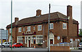
The King George V at Bescot, Walsall
This large three roomed public house was built in 1936 by Mitchells and Butlers brewery. It can be very crowded on a Saturday when Walsall are playing at home in the local stadium. The games room has a display of traditional pub games.
Image: © Roger D Kidd
Taken: 29 Jul 2011
0.04 miles
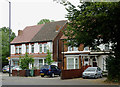
3
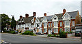
Housing and hotel in Bescot Road, Walsall
This row looks like a prime candidate for redevelopment. Even in the 1960s many of the dwellings were used as flats and bedsits, and the Abberley Hotel here is boarded up and disused. Some of the smaller terraced houses at the far end, and off to the right appear to be in good condition and privately owned now. I lived along here for a year or so in 1970-1971 but can't remember whether it was No 21 or 25, at the far end.
Image: © Roger D Kidd
Taken: 29 Jul 2011
0.05 miles
4
Housing and hotel in Bescot Road, Walsall
This row looks like a prime candidate for redevelopment. Even in the 1960s many of the dwellings were used as flats and bedsits, and the Abberley Hotel here is boarded up and disused. Some of the smaller terraced houses appear to be in good condition and privately owned now.
Image: © Roger D Kidd
Taken: 29 Jul 2011
0.07 miles
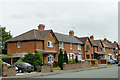
5
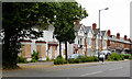
Housing in Bescot Road in Pleck, Walsall
These two semi-detached cottages (privately owned?) have been maintained to a good standard, though other properties off to the right are dilapidated and disused. I'm sure I lived in one of these c1970, just for a year or so, but I need to remember which one.
Image: © Roger D Kidd
Taken: 29 Jul 2011
0.08 miles
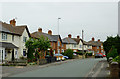
6
Dickinson Drive in Bescot, Walsall
Seen from near the junction with Smith Road. Considerable upgrading has been done to renovate these old properties.
Image: © Roger D Kidd
Taken: 29 Jul 2011
0.12 miles
7
Dickinson Drive in Bescot, Walsall
Seen from the junction with Smith Road.
Image: © Roger D Kidd
Taken: 29 Jul 2011
0.13 miles
8
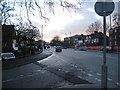
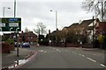
Bescot Road - Walsall, West Midlands
A view southwards down Bescot Road, Walsall looking in the direction of Junction 9 of the M6 motorway. This photo was taken at the junction of Bescot Road, Darlaston Road, Old Pleck Road and Wednesbury Road. This junction was at that time being remodelled to provide more lanes and ease traffic flow. Time taken 4.12 pm GMT (Greenwich Mean Time).
Image: © Martin Richard Phelan
Taken: 30 Jan 2015
0.16 miles
9
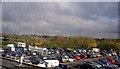
A view east from the Ikea cafe
Surprisingly green view in this intensely urban scene with the M6 on its elevated viaduct across from left to right.
Image: © Andrew Darge
Taken: 31 Oct 2008
0.16 miles
10
Fellows Park from the railway
A Morrisons supermarket now stands on the site of Fellows Park.
Image: © Steve Daniels
Taken: 30 Jan 1982
0.17 miles