IMAGES TAKEN NEAR TO
Green Lane, WALSALL, WS2 8NP
Introduction
This page details the photographs taken nearby to Green Lane, WS2 8NP by members of the Geograph project.
The Geograph project started in 2005 with the aim of publishing, organising and preserving representative images for every square kilometre of Great Britain, Ireland and the Isle of Man.

There are currently over 7.5m images from over14,400 individuals and you can help contribute to the project by visiting https://www.geograph.org.uk
Image Map
Images are licensed for reuse under creativecommons.org/licenses/by-sa/2.0
Notes
- Clicking on the map will re-center to the selected point.
- The higher the marker number, the further away the image location is from the centre of the postcode.
Image Listing (72 Images Found)
Images are licensed for reuse under creativecommons.org/licenses/by-sa/2.0
Image
Details
Distance
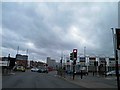
1
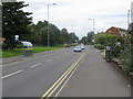
Walsall - Green Lane
This is the A34 running north from Walsall: the main route from Manchester to Birmingham before the M6 and occasionally nowadays when the M6 becomes blocked. Astonishingly, this pathetically narrow road is still a UK trunk route in 2008.
Image: © Peter Whatley
Taken: 29 Sep 2008
0.04 miles
2
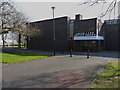
Green Lane Baptist Church
A small, modern church in the centre of Birchills, north of Walsall
Image: © Richard Law
Taken: 18 Feb 2013
0.05 miles
4
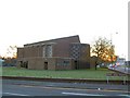
St. Patrick's, Walsall
Sunrise behind the Catholic church of St. Patrick, on the A34 just north of Walsall centre. The police station lies directly behind the church. View looking south.
Image: © Roger May
Taken: 18 Dec 2005
0.09 miles
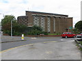
5
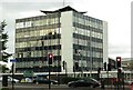
Walsall Police Station
The police station is on the corner of Green Lane and Court Way.
Image: © Steve Daniels
Taken: 20 Sep 2013
0.12 miles
6
Junction Blue Lane (A34) with Blue Lane West, Walsall
Image: © Steve Fareham
Taken: 3 Feb 2014
0.13 miles
7
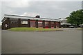
Walsall fire station
Walsall fire station, Blue Lane West, Walsall forms part of the West Midlands Fire & Rescue Service.
Image: © Kevin Hale
Taken: 12 Jun 2006
0.14 miles
8
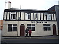
The Crown Inn
The Crown Inn, Long Acre Street, Walsall
Image: © Roger W Haworth
Taken: 19 Feb 2019
0.14 miles
9
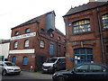
Victoria Corn Mills
Victoria Corn Mills, Long Acre Street, Walsall. The projecting gable is a lucam (or lucarne) https://new.millsarchive.org/glossary/a-z-glossary/?action=show&which=3472 which would have protected the hoist used to raise sacks to the first floor. The doorway on the first floor is to load sacks directly into wagons. There is a weighbridge below it, set where the wagons would have been loaded, a good example of Victorian efficiency. Notice also the rather nice cast iron letter box set into the wall at the side of the entrance, still bearing the name of the original miller, J F Dolman. (Description cribbed from Flickr https://www.flickr.com/photos/61649287@N03/5940083620 and https://www.flickr.com/photos/61649287@N03/5940136716/ .)
Part of the building is now occupied by Urban Hax http://urbanhax.com/ a makerspace.
Interior view: Image
Image: © Roger W Haworth
Taken: 19 Feb 2019
0.14 miles
10
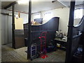
Stables of Victoria Corn Mills
The stables of Victoria Corn Mills, Long Acre Street, Walsall. The paved floor and stalls are still in place. Exterior view: Image
Image: © Roger W Haworth
Taken: 19 Feb 2019
0.15 miles