IMAGES TAKEN NEAR TO
Penkridge Close, WALSALL, WS2 8JT
Introduction
This page details the photographs taken nearby to Penkridge Close, WS2 8JT by members of the Geograph project.
The Geograph project started in 2005 with the aim of publishing, organising and preserving representative images for every square kilometre of Great Britain, Ireland and the Isle of Man.

There are currently over 7.5m images from over14,400 individuals and you can help contribute to the project by visiting https://www.geograph.org.uk
Image Map
Images are licensed for reuse under creativecommons.org/licenses/by-sa/2.0
Notes
- Clicking on the map will re-center to the selected point.
- The higher the marker number, the further away the image location is from the centre of the postcode.
Image Listing (35 Images Found)
Images are licensed for reuse under creativecommons.org/licenses/by-sa/2.0
Image
Details
Distance
1
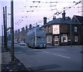
Walsall trolleybus passing Proffitt Street
Walsall in the days when electric buses were previously in fashion
Image: © Paul Brown
Taken: 14 Mar 1970
0.06 miles
2
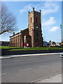
St Peter's church, Walsall
Built (and consecrated) in 1841 to the Early English style, this is the local parish church. Major repair works, particularly to the tower, have been undertaken in the last few years. It was built in 1830/40, consecrated in 1841, extended by the addition of the chancel in 1910 and Grade II listed https://britishlistedbuildings.co.uk/101077168-church-of-st-peter-birchills-leamore-ward#.YG7yG-hKjcs & https://historicengland.org.uk/listing/the-list/list-entry/1077168 in 1986.
Image: © Richard Law
Taken: 18 Feb 2013
0.09 miles
3
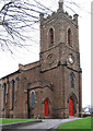
Walsall - St Peter's Church spire
For an alternative view, please see Image
Image: © Dave Bevis
Taken: 12 Apr 2014
0.09 miles

5
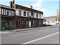
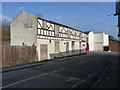
The Tapsters at the Sportsman pub
The sad remains of a former pub on Stafford Street, Birchills.
Image: © Richard Law
Taken: 18 Feb 2013
0.12 miles
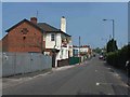
6
The Bell Inn (well, it was...)
The remains of the former M&B pub, The Bell, at the junction of Whitehouse Street and Stafford Street (the B4210)
Image: © Richard Law
Taken: 18 Feb 2013
0.14 miles
8
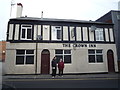
The Crown Inn
The Crown Inn, Long Acre Street, Walsall
Image: © Roger W Haworth
Taken: 19 Feb 2019
0.18 miles
9
The British Oak, Walsall
Unlike the thriving 'Pretty Bricks' pub a few yards up the road this former Banks' pub on John Street has fallen on very hard times. In 2013 a planning application to turn it into student accommodation was turned down on the grounds that the area is too industrial. It is now not only derelict but has at some point been gutted by fire. This view from four years earlier shows the pub disused but in a better state than it is now: Image
Image: © Stephen McKay
Taken: 9 Feb 2020
0.18 miles
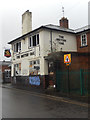
10
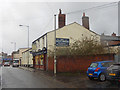
The Pretty Bricks, Walsall
Storm Ciara, reputedly the worst for seven years, was in full swing sending gusts of wind and rain squalls down the street but at least this pub offered a dry and welcoming refuge. It dates from 1845 and is more properly known as the New Inn but takes its popular name from the glazed bricks around the front ground floor windows. It is now part of the Black Country Ales portfolio.
Image: © Stephen McKay
Taken: 9 Feb 2020
0.18 miles