IMAGES TAKEN NEAR TO
Leamore Industrial Estate, Leamore Close, WALSALL, WS2 7NL
Introduction
This page details the photographs taken nearby to Leamore Industrial Estate, Leamore Close, WS2 7NL by members of the Geograph project.
The Geograph project started in 2005 with the aim of publishing, organising and preserving representative images for every square kilometre of Great Britain, Ireland and the Isle of Man.

There are currently over 7.5m images from over14,400 individuals and you can help contribute to the project by visiting https://www.geograph.org.uk
Image Map
Images are licensed for reuse under creativecommons.org/licenses/by-sa/2.0
Notes
- Clicking on the map will re-center to the selected point.
- The higher the marker number, the further away the image location is from the centre of the postcode.
Image Listing (29 Images Found)
Images are licensed for reuse under creativecommons.org/licenses/by-sa/2.0
Image
Details
Distance
1
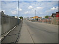
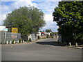
Fryer's Road, Leamore (2)
Looking towards Bloxwich from the junction with Commercial Road. Ahead, the road rises to cross the Wyrley & Essington Canal by way of a humpback bridge.
Image: © Richard Vince
Taken: 29 May 2021
0.10 miles
2
Fryer's Road, Leamore (1)
Looking towards Bloxwich from the junction with Commercial Road. Ahead, the road rises to cross the Wyrley & Essington Canal by way of a humpback bridge.
Image: © Richard Vince
Taken: 29 May 2021
0.10 miles
3
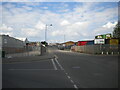
Entrance to recycling centre, Leamore
Off Fryer's Road.
Image: © Richard Vince
Taken: 29 May 2021
0.11 miles
4
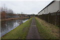
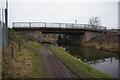
Wyrley & Essington Canal towards Well End Bridge
Image: © Ian S
Taken: 16 Dec 2021
0.14 miles
5

Fryer's Road, Leamore (3)
Looking towards Bloxwich from Leamore Lane. In the distance, the road rises to cross the Wyrley & Essington Canal by way of a humpback bridge.
Image: © Richard Vince
Taken: 29 May 2021
0.14 miles
6
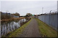
Wyrley & Essington Canal towards Well End Bridge
Image: © Ian S
Taken: 16 Dec 2021
0.14 miles
7
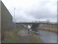
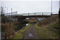
Wyrley & Essington Canal - Wall End Bridge
Prestressed concrete beam bridge carrying Fryer's Road.
Image: © John M
Taken: 8 Mar 2009
0.17 miles
8
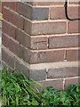
OS benchmark - 133 Leamore Lane
An OS cutmark in the brick frontage of no 133, Leamore Lane. Originally levelled at 136.843m above Ordnance Datum Newlyn.
Image: © Richard Law
Taken: 5 Sep 2013
0.17 miles