IMAGES TAKEN NEAR TO
Telford Road, WALSALL, WS2 7LD
Introduction
This page details the photographs taken nearby to Telford Road, WS2 7LD by members of the Geograph project.
The Geograph project started in 2005 with the aim of publishing, organising and preserving representative images for every square kilometre of Great Britain, Ireland and the Isle of Man.

There are currently over 7.5m images from over14,400 individuals and you can help contribute to the project by visiting https://www.geograph.org.uk
Image Map
Images are licensed for reuse under creativecommons.org/licenses/by-sa/2.0
Notes
- Clicking on the map will re-center to the selected point.
- The higher the marker number, the further away the image location is from the centre of the postcode.
Image Listing (29 Images Found)
Images are licensed for reuse under creativecommons.org/licenses/by-sa/2.0
Image
Details
Distance
1
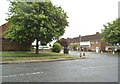
Priestley Road
The view from Bloxwich Lane in Leamore, Walsall.
Image: © Gordon Griffiths
Taken: 29 May 2014
0.04 miles
2
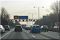
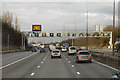
Smart motorway in operation
There is heavy traffic on the M6 approaching Junction 10.
Image: © Bill Boaden
Taken: 27 Dec 2016
0.07 miles
4
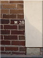
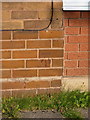
OS benchmark - no 183 Bloxwich Lane
An OS cutmark in the bricks of no 183 Bloxwich Lane, originally levelled at 136.691m above Ordnance Datum Newlyn.
Image: © Richard Law
Taken: 5 Sep 2013
0.10 miles
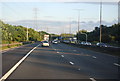
5
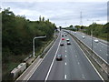
Active Traffic Management on the Northbound M6
Active Traffic Management (ATM) is a system used on certain motorways where gantry signs are computer-controlled to set a variable speed limit, open the hard shoulder as a running lane and limit the volume of traffic entering at junctions, with the aim of improving the flow of traffic (see http://www.cbrd.co.uk/indepth/atm/ for more detailed information about the Active Traffic Management system).
Image: © David Dixon
Taken: 21 Dec 2012
0.10 miles
7
OS benchmark - no 119 Bloxwich Lane
An OS cutmark in the brickwork of no 119 Bloxwich Lane, originally levelled at 136.852m above Ordnance Datum Newlyn.
Image: © Richard Law
Taken: 5 Sep 2013
0.10 miles
8
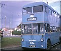
Walsall trolleybus turning at Cavendish Road
BUT trolleybus 874 (GFU 692) on a private tour, turning at Cavendish Road at the junction with Bloxwich Lane. This was the last trolleybus extension in Walsall from Stephenson Avenue which took place on 2nd September, 1963, only to last seven years before the system's closure on 3rd October, 1970.
Image: © David Hillas
Taken: 3 Oct 1970
0.12 miles
9

A Motorbus and Trolleybus at Bloxwich Lane/Cavendish Road
Taken on the 3rd October 1970, this photo shows an ex-Birmingham City Transport Guy Arab IV motorbus and 874 (GFU 692) BUT 9611T trolleybus with Northern Coachbuilders 54-seater bodywork, at the Cavendish Road terminus of trolleybus route 33 from Walsall town centre. This extension from Stephenson Avenue was opened on the 2nd September 1963 and was the last such extension on the Walsall trolleybus system. However, it saw only seven years service as the trolleybus system closed on the 3rd October 1970. National Express West Midlands now operates routes 70/70A from this location to Walsall town centre. This turning circle is now occupied by the Magic Lantern public house.
Image: © David Hillas
Taken: 3 Oct 1970
0.13 miles
10

Northbound M6, Bentley Lane Bridge
The bridge taking Bentley Lane over the northbound M6 at Willenhall.
Image: © David Dixon
Taken: 21 Dec 2012
0.13 miles