IMAGES TAKEN NEAR TO
Stephenson Avenue, WALSALL, WS2 7HD
Introduction
This page details the photographs taken nearby to Stephenson Avenue, WS2 7HD by members of the Geograph project.
The Geograph project started in 2005 with the aim of publishing, organising and preserving representative images for every square kilometre of Great Britain, Ireland and the Isle of Man.

There are currently over 7.5m images from over14,400 individuals and you can help contribute to the project by visiting https://www.geograph.org.uk
Image Map
Images are licensed for reuse under creativecommons.org/licenses/by-sa/2.0
Notes
- Clicking on the map will re-center to the selected point.
- The higher the marker number, the further away the image location is from the centre of the postcode.
Image Listing (29 Images Found)
Images are licensed for reuse under creativecommons.org/licenses/by-sa/2.0
Image
Details
Distance
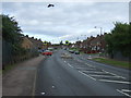
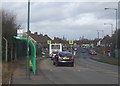
4
British Trolleybuses - Walsall
At full stretch! Resurfacing on Stephenson Avenue meant that trolleybuses towards town had their poles at full stretch when coming past the works. Drivers had to be particularly careful to ensure that they did not lose contact, but this shows that there was a considerable measure of flexibility available. Most British trolleybus systems did not have back-up batteries to allow even short distances to be covered away from the wires.
For a slide show of British Trolleybuses in the late 60s http://www.geograph.org.uk/search.php?i=1773236&displayclass=slide
Image: © Alan Murray-Rust
Taken: 31 Jan 1970
0.10 miles
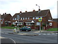
5
Stephenson Avenue - Leamore
The scene has changed a little since the 1960s Image There is now a mini-roundabout, bus shelter and single deck TravelWM bus.
Image: © John M
Taken: 8 Mar 2009
0.10 miles
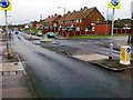
6
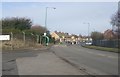
Stephenson Avenue - Leamore
The scene has changed a little since the 1960s Image with a factory entrance, mini roundabout and bus shelter.
Image: © John M
Taken: 8 Mar 2009
0.11 miles
7
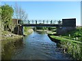
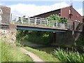
Stubbs [or Stubbs'] Bridge, from the north
Carrying a footpath over the Wyrley & Essington Canal, just north of Birchills Junction.
Image: © Christine Johnstone
Taken: 6 May 2018
0.12 miles
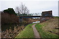
9
Stubbs Bridge - Wyrley and Essington Canal
Provides pedestrian access to Green Lane next to the old waterworks.
Image: © John M
Taken: 22 Jun 2008
0.13 miles
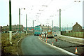
10
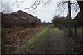
Wyrley & Essington Canal towards Stubbs Bridge
Image: © Ian S
Taken: 16 Dec 2021
0.15 miles