1
Police Outpost
Small Police outpost in the grey building to the right of the BCHA centre. On Stevenson Avenue at Leamore, Walsall. The main Police Station is a mile or so away, down the A34 towards Walsall centre.
Image: © Roger May
Taken: 18 Dec 2005
0.09 miles
2
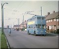
Walsall Trolleybus in Stephenson Avenue
Crossley-Empire trolleybus 850 (HBE 541) on a private tour travelling towards Walsall. The vehicle came from Grimsby-Cleethorpes Transport in 1961 after the trolleybus system was abandoned there.
Image: © David Hillas
Taken: 20 Sep 1969
0.12 miles
3
St Chad's Hall
This hall may well have been the original St Chad's church, before the building of the new church a few hundred yards away at
Image
Image: © Richard Law
Taken: 5 Sep 2013
0.13 miles
4
The Rock Church, Edison Road, Walsall
No information to be had on this church - no denomination?
Image: © Jonathan Billinger
Taken: 1 May 2008
0.13 miles
5
Eastern half of Fleming Road, Beechdale estate
Seen from Stephenson Avenue, which cuts Fleming Road in half.
Image: © Richard Vince
Taken: 29 May 2021
0.16 miles
6
St. Catherine with St. Chad's church, Blakenhall Heath
An octagonal estate church, built in 1957 in Edison Road, Leamore.
Image: © Jonathan Billinger
Taken: 1 May 2008
0.17 miles
7
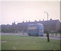
Walsall trolleybus at Leamore
Pictured in Stephenson Avenue, Walsall trolleybus 850 (HBE541) is on a private trip. The power station chimneys in the right background disappeared somewhile ago.
Image: © David Hillas
Taken: 20 Sep 1969
0.17 miles
8
The church of St Catherine with St Chad
One of several churches in the Leamore area; this one is on Edison Road.
Image: © Richard Law
Taken: 5 Sep 2013
0.17 miles
9
Stephenson Avenue service road, Beechdale estate (2)
Seen at its junction with the western half of Fleming Road, whose other half is on the other side of the green space on the left (which also separates the service road from Stephenson Avenue proper).
Image: © Richard Vince
Taken: 29 May 2021
0.18 miles
10
Walsall Trolleybus near Fleming Road
Crossley Empire TDD43/2 trolleybus 850 (HBE541) on a private tour in Stephenson Avenue near Fleming Road at Leamore North of Walsall.
Image: © David Hillas
Taken: 20 Sep 1969
0.22 miles


