IMAGES TAKEN NEAR TO
Leamore Lane, WALSALL, WS2 7AB
Introduction
This page details the photographs taken nearby to Leamore Lane, WS2 7AB by members of the Geograph project.
The Geograph project started in 2005 with the aim of publishing, organising and preserving representative images for every square kilometre of Great Britain, Ireland and the Isle of Man.

There are currently over 7.5m images from over14,400 individuals and you can help contribute to the project by visiting https://www.geograph.org.uk
Image Map
Images are licensed for reuse under creativecommons.org/licenses/by-sa/2.0
Notes
- Clicking on the map will re-center to the selected point.
- The higher the marker number, the further away the image location is from the centre of the postcode.
Image Listing (19 Images Found)
Images are licensed for reuse under creativecommons.org/licenses/by-sa/2.0
Image
Details
Distance
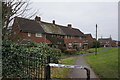
1
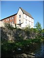
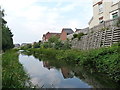
End-terrace three-storey house on Leamore Lane
Seen from a boat on the Wyrley & Essington Canal.
Image: © Christine Johnstone
Taken: 6 May 2018
0.02 miles
2
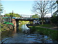
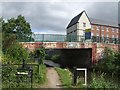
Stokes [or Stoke's] Bridge, from the north
Carrying Leamore Lane over the Wyrley & Essington Canal.
Image: © Christine Johnstone
Taken: 6 May 2018
0.03 miles
5
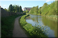
Wyrley & Essington canal
Just north of Image this is a section of the 'Curly Wyrley' cut.
Image: © Richard Law
Taken: 5 Sep 2013
0.04 miles
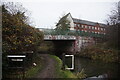
6
Stoke's Bridge -Wyrley and Essington Canal
The paint scheme is not graffiti but part of an art project but is now beginning to look untidy.
Image: © John M
Taken: 22 Jun 2008
0.05 miles
8
Wyrley & Essington Canal towards Stubbs Bridge
Image: © Ian S
Taken: 16 Dec 2021
0.06 miles
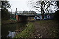
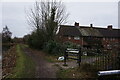
10
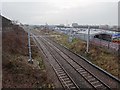
Walsall-Rugeley railway line from the Leamore Lane bridge
Looking south east towards Birchills and Walsall.
Image: © Nigel Thompson
Taken: 25 Jan 2019
0.09 miles