IMAGES TAKEN NEAR TO
Wolverhampton Road West, WALSALL, WS2 0DT
Introduction
This page details the photographs taken nearby to Wolverhampton Road West, WS2 0DT by members of the Geograph project.
The Geograph project started in 2005 with the aim of publishing, organising and preserving representative images for every square kilometre of Great Britain, Ireland and the Isle of Man.

There are currently over 7.5m images from over14,400 individuals and you can help contribute to the project by visiting https://www.geograph.org.uk
Image Map
Images are licensed for reuse under creativecommons.org/licenses/by-sa/2.0
Notes
- Clicking on the map will re-center to the selected point.
- The higher the marker number, the further away the image location is from the centre of the postcode.
Image Listing (33 Images Found)
Images are licensed for reuse under creativecommons.org/licenses/by-sa/2.0
Image
Details
Distance
1
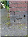
OS benchmark - Bentley, cemetery wall
An OS cutmark on the wall at the NE corner of the former Willenhall Urban District Council's cemetery boundary. Originally levelled in the mid 1950s at 133.402m above Ordnance Datum Newlyn.
Image: © Richard Law
Taken: 9 Jun 2016
0.06 miles
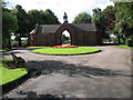
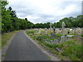
2
Bentley Cemetery Gates
B4464 Wolverhampton Road West.
Bentley Cemetery was opened in 1900 by the then Willenhall Urban District Council.
Image: © Adrian Rothery
Taken: 14 Aug 2008
0.11 miles
3
Bentley Cemetery Toilets
Erected 1898, now closed due to 'vandalism and improper use'.
Image: © Adrian Rothery
Taken: 14 Aug 2008
0.13 miles
4
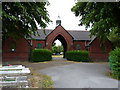
Bentley Cemetery Chapel of Rest
Long since closed as a Chapel of Rest (and having had a life as public toilets these too are closed), it's still a striking building.
Image: © Richard Law
Taken: 7 Jul 2010
0.13 miles
7
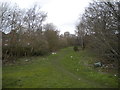
Course of Bentley Canal, County Bridge
Now forming an unofficial footpath. Seen from Hopyard Bridge, which is still very much intact even though the canal is long gone.
Image: © Richard Vince
Taken: 9 Feb 2019
0.16 miles
8
The western side of Bentley Cemetery
Compare the view to the north with that in Image, taken 3½ years ago - no more blocks of flats, exactly as promised.
Image: © Richard Law
Taken: 7 Jul 2010
0.18 miles
9
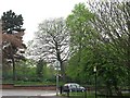
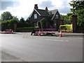
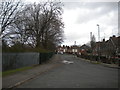
Wolverhampton Road West
The junction with Churchill Road with Bentley Cemetery in the background.
Image: © Richard Webb
Taken: 18 Apr 2011
0.18 miles
10
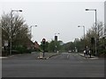
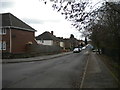
Queen Elizabeth Avenue
Looking over the junction with Wolverhampton Road West.
Image: © Richard Webb
Taken: 18 Apr 2011
0.18 miles