IMAGES TAKEN NEAR TO
Anson Road, WALSALL, WS2 0DH
Introduction
This page details the photographs taken nearby to Anson Road, WS2 0DH by members of the Geograph project.
The Geograph project started in 2005 with the aim of publishing, organising and preserving representative images for every square kilometre of Great Britain, Ireland and the Isle of Man.

There are currently over 7.5m images from over14,400 individuals and you can help contribute to the project by visiting https://www.geograph.org.uk
Image Map
Images are licensed for reuse under creativecommons.org/licenses/by-sa/2.0
Notes
- Clicking on the map will re-center to the selected point.
- The higher the marker number, the further away the image location is from the centre of the postcode.
Image Listing (28 Images Found)
Images are licensed for reuse under creativecommons.org/licenses/by-sa/2.0
Image
Details
Distance
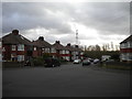
1
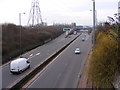
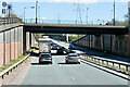
Black Country Route View
The view west of the A454 from Bentley Road North Bridge.
Image: © Gordon Griffiths
Taken: 27 Jan 2010
0.10 miles
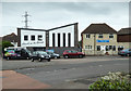
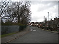
2
The Church on the Corner
The Church on King Charles Avenue, Walsall.
Image: © Gordon Griffiths
Taken: 27 Jan 2010
0.11 miles
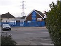
3
The Church on the Corner
Apostolic Church on the corner of King Charles Avenue and Bentley Road North. http://www.thechurchonthecorner.org.uk/Site/Welcome.html
This appears to be a new building, see Image] from 2010.
Image: © David P Howard
Taken: 1 Jun 2016
0.11 miles
4
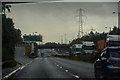
Willenhall : Black Country Route A454
Looking along the A454.
Image: © Lewis Clarke
Taken: 27 Sep 2019
0.12 miles
8
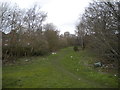
Course of Bentley Canal, County Bridge
Now forming an unofficial footpath. Seen from Hopyard Bridge, which is still very much intact even though the canal is long gone.
Image: © Richard Vince
Taken: 9 Feb 2019
0.15 miles
9
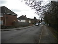
East end of Devon Road, County Bridge
Seen from the end of Coronation Avenue.
Image: © Richard Vince
Taken: 9 Feb 2019
0.15 miles
10
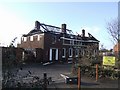
Fire damage at the Lane Arms
The pub is named after the local landowner of nearby Bentley Hall. In September 1651 Mistress Jane Lane assisted King Charles II in his escape to exile in France following defeat at the Battle of Worcester. Disguised as her groom the king accompanied Jane to Abbots Leigh near Bristol and then on to Trent, near Yeovil.
Image: © John M
Taken: 26 Dec 2009
0.16 miles