
IMAGES TAKEN NEAR TO
St. Barbara Road, RUGELEY, WS15 4HB
Introduction
This page details the photographs taken nearby to St. Barbara Road, WS15 4HB by members of the Geograph project.
The Geograph project started in 2005 with the aim of publishing, organising and preserving representative images for every square kilometre of Great Britain, Ireland and the Isle of Man.

There are currently over 7.5m images from over14,400 individuals and you can help contribute to the project by visiting https://www.geograph.org.uk
Image Map
Images are licensed for reuse under creativecommons.org/licenses/by-sa/2.0
Notes
- Clicking on the map will re-center to the selected point.
- The higher the marker number, the further away the image location is from the centre of the postcode.
Image Listing (174 Images Found)
Images are licensed for reuse under creativecommons.org/licenses/by-sa/2.0
Image
Details
Distance
1
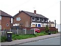
The Poplars, Handsacre
Sadly, this pub closed for the last time in early 2008
Image: © Geoff Pick
Taken: 16 May 2008
0.08 miles
2
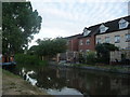
Canalside houses, Handsacre
The housing is on a little bit of infill called Waters Edge, the canal is the Trent and Mersey.
Image: © Christine Johnstone
Taken: 21 Jul 2018
0.08 miles
3
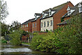
Canalside housing in Handsacre, Staffordshire
The mdern housing is in Waters Edge (no apostrophe).
Image: © Roger Kidd
Taken: 17 Oct 2011
0.09 miles
4

Trent & Mersey Canal, Handsacre
Modern houses overlook the canal to the east of bridge 58.
Image: © Stephen McKay
Taken: 16 Aug 2013
0.10 miles
5
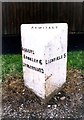
Old Milepost by the B5014, Uttoxeter Road, Handsacre
Cast iron post by the B5014, in parish of ARMITAGE WITH HANDSACRE (LICHFIELD District), Handsacre, in front of fence, on West side of road. Lathe iron casting, erected by the County Council in the 19th/20th century.
Inscription reads:-
: ABBOTS / BROMLEY 6 / UTTOXETER 13 : : ARMITAGE: : LICHFIELD 5 :
Maker:-
: Chas. Lathe, Tipton. :
Staffordshire HER listed
HER Number: 51390 https://www.heritagegateway.org.uk/Gateway/Results_Single.aspx?uid=MST12644&resourceID=1010
Milestone Society National ID: ST_LFUT05.
Image: © J Higgins
Taken: 1 Jan 2000
0.10 miles
6

Trent and Mersey Canal at Handsacre in Staffordshire
Looking west as the canal meanders round the northern side of Handsacre. The modern housing is in Waters Edge!
Image: © Roger Kidd
Taken: 20 Jun 2010
0.10 miles
7

Narrowboats near Handsacre in Staffordshire
This is the Trent and Mersey Canal south-east of Handsacre Crown Bridge, No 58. The housing is in Waters Edge.
Image: © Roger Kidd
Taken: 14 Jun 2010
0.10 miles
8

Recent canalside housing at Handsacre, Staffordshire
The Trent and Mersey Canal passes the northern edge of Handsacre. These houses are in the astonishingly imaginatively named road - Water's Edge!
Image: © Roger D Kidd
Taken: 20 Jun 2010
0.10 miles
9

Mooring near Handsacre in Staffordshire
This is the Trent and Mersey Canal south-east of Handsacre Crown Bridge, No 58.
Image: © Roger Kidd
Taken: 14 Jun 2010
0.10 miles
10

Trent and Mersey Canal approaching Handsacre in Staffordshire
The housing is in the imaginatively named road "Waters Edge"!
Image: © Roger Kidd
Taken: 31 Aug 2012
0.10 miles