
IMAGES TAKEN NEAR TO
Coulthwaite Way, RUGELEY, WS15 1SJ
Introduction
This page details the photographs taken nearby to Coulthwaite Way, WS15 1SJ by members of the Geograph project.
The Geograph project started in 2005 with the aim of publishing, organising and preserving representative images for every square kilometre of Great Britain, Ireland and the Isle of Man.

There are currently over 7.5m images from over14,400 individuals and you can help contribute to the project by visiting https://www.geograph.org.uk
Image Map
Images are licensed for reuse under creativecommons.org/licenses/by-sa/2.0
Notes
- Clicking on the map will re-center to the selected point.
- The higher the marker number, the further away the image location is from the centre of the postcode.
Image Listing (8 Images Found)
Images are licensed for reuse under creativecommons.org/licenses/by-sa/2.0
Image
Details
Distance
1

Rugeley Power Station, 1989
View NE, from a side-street off the A460 by-pass.
(Cf. Image)
Image: © Ben Brooksbank
Taken: 31 Mar 1989
0.08 miles
6
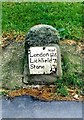
Old Milestone by the A51, Main Road, Brereton
Metal plate attached to stone post by the A51, in parish of BRERETON AND RAVENHILL (CANNOCK CHASE District), Main Road, near Brereton, between path and grass, on Southwest side of road. Stone and iron plate, erected by the Coleshill to Stone (First District of Lichfield) turnpike trust in the 19th century.
Inscription reads:-
Miles
London 126
Lichfield 7
Stone 15
Grade II listed.
List Entry Number: 1060210 https://historicengland.org.uk/listing/the-list/list-entry/1060210
Milestone Society National ID: ST_LFSN07.
Image: © J Higgins
Taken: 1 Jan 2000
0.19 miles
7
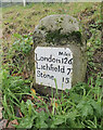
Old Milestone by the A51, Main Road, Brereton
Metal plate attached to stone post by the A51, in parish of BRERETON AND RAVENHILL (CANNOCK CHASE District), Main Road, near Brereton, between path and grass, on Southwest side of road. Stone and iron plate, erected by the Coleshill to Stone (First District of Lichfield) turnpike trust in the 19th century.
Inscription reads:-
Miles
London 126
Lichfield 7
Stone 15
Grade II listed.
List Entry Number: 1060210 https://historicengland.org.uk/listing/the-list/list-entry/1060210
Milestone Society National ID: ST_LFSN07.
Image: © Billy Hufton
Taken: 20 Nov 2023
0.19 miles
8
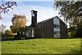
Church of the Good Shepherd
Opened in 1959 at the heart of the Pear Tree Estate. The estate was built to provide housing for the newly opened Lea Hall Colliery.
Image: © John M
Taken: 7 Nov 2013
0.19 miles