IMAGES TAKEN NEAR TO
Setterfield Way, RUGELEY, WS15 1BJ
Introduction
This page details the photographs taken nearby to Setterfield Way, WS15 1BJ by members of the Geograph project.
The Geograph project started in 2005 with the aim of publishing, organising and preserving representative images for every square kilometre of Great Britain, Ireland and the Isle of Man.

There are currently over 7.5m images from over14,400 individuals and you can help contribute to the project by visiting https://www.geograph.org.uk
Image Map
Images are licensed for reuse under creativecommons.org/licenses/by-sa/2.0
Notes
- Clicking on the map will re-center to the selected point.
- The higher the marker number, the further away the image location is from the centre of the postcode.
Image Listing (7 Images Found)
Images are licensed for reuse under creativecommons.org/licenses/by-sa/2.0
Image
Details
Distance
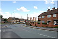
1
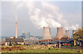
Rugeley Power Station, 1989
View NE, from a side-street off the A460 by-pass.
(Cf. Image)
Image: © Ben Brooksbank
Taken: 31 Mar 1989
0.16 miles
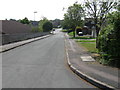
7
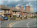
Semi-detached houses in Rugeley
The cooling towers of Rugeley power station in the distance.
Image: © Patrick Mackie
Taken: 28 Aug 2006
0.19 miles