IMAGES TAKEN NEAR TO
Upper St. John Street, LICHFIELD, WS14 9EE
Introduction
This page details the photographs taken nearby to Upper St. John Street, WS14 9EE by members of the Geograph project.
The Geograph project started in 2005 with the aim of publishing, organising and preserving representative images for every square kilometre of Great Britain, Ireland and the Isle of Man.

There are currently over 7.5m images from over14,400 individuals and you can help contribute to the project by visiting https://www.geograph.org.uk
Image Map
Images are licensed for reuse under creativecommons.org/licenses/by-sa/2.0
Notes
- Clicking on the map will re-center to the selected point.
- The higher the marker number, the further away the image location is from the centre of the postcode.
Image Listing (69 Images Found)
Images are licensed for reuse under creativecommons.org/licenses/by-sa/2.0
Image
Details
Distance
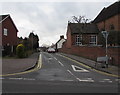
1
King Edward VI School entrance road, Lichfield
From Upper St John Street. Maximum speed 5mph.
Image: © Jaggery
Taken: 17 Feb 2018
0.03 miles
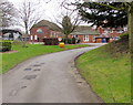
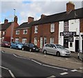
2
Houses on Upper St John Street
Houses on Upper St John Street in Lichfield.
Image: © Philip Halling
Taken: 25 Aug 2018
0.06 miles
3
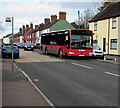
X65 bus for Tamworth in Lichfield
The Arriva bus on the A51 Upper St John Street in Lichfield is on bus route X65 from
Lichfield City Centre Bus Station to Tamworth Town Centre Bus Interchange via Hopwas.
Image: © Jaggery
Taken: 17 Feb 2018
0.07 miles
4
The Polish Shop, Lichfield
Polish Shop (Polski Sklep) at 169 Upper St John Street.
Image: © Jaggery
Taken: 17 Feb 2018
0.07 miles
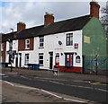
5
Blolox hairdressing salon, 163 Upper St John Street, Lichfield
Prices on display in February 2018 are Ladies cut & blowdry £20, Gents cut £10.
Image: © Jaggery
Taken: 17 Feb 2018
0.07 miles
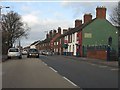
6
Zebra crossing, Upper St John Street, Lichfield
The Polish Shop (Polski Sklep) https://www.geograph.org.uk/photo/5682432 is on the right.
Image: © Jaggery
Taken: 17 Feb 2018
0.08 miles
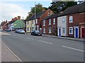
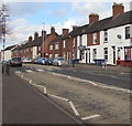
7
Lichfield - Upper St John's Street houses
Image: © Peter Whatley
Taken: 7 Dec 2011
0.09 miles
8
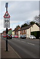
Warning sign - School 20 when lights show, Upper St John Street, Lichfield
Facing northbound traffic on the A51 Upper St John Street on the approach to King Edward VI School.
Image: © Jaggery
Taken: 17 Feb 2018
0.09 miles
9
Junction of Upper St John Street and Chapel Lane, Lichfield
Along Chapel Lane from Upper St John Street. Holy Cross church https://www.geograph.org.uk/photo/5691572 is on the right.
Image: © Jaggery
Taken: 17 Feb 2018
0.10 miles
10
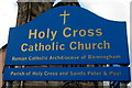
Holy Cross Catholic Church name sign, Lichfield
Located here https://www.geograph.org.uk/photo/5691572 on the corner of Upper St John Street and Chapel Lane.
Image: © Jaggery
Taken: 17 Feb 2018
0.10 miles