IMAGES TAKEN NEAR TO
Kenilworth Road, LICHFIELD, WS14 9DP
Introduction
This page details the photographs taken nearby to Kenilworth Road, WS14 9DP by members of the Geograph project.
The Geograph project started in 2005 with the aim of publishing, organising and preserving representative images for every square kilometre of Great Britain, Ireland and the Isle of Man.

There are currently over 7.5m images from over14,400 individuals and you can help contribute to the project by visiting https://www.geograph.org.uk
Image Map
Images are licensed for reuse under creativecommons.org/licenses/by-sa/2.0
Notes
- Clicking on the map will re-center to the selected point.
- The higher the marker number, the further away the image location is from the centre of the postcode.
Image Listing (121 Images Found)
Images are licensed for reuse under creativecommons.org/licenses/by-sa/2.0
Image
Details
Distance
1
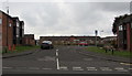
Barnfield Close, Lichfield
Cul-de-sac on the west side of the A51 Upper St John Street.
Image: © Jaggery
Taken: 17 Feb 2018
0.05 miles
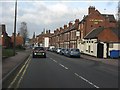
2
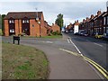
Upper St John Street
Upper St John Street, the A51 in Lichfield.
Image: © Philip Halling
Taken: 25 Aug 2018
0.06 miles
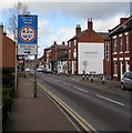
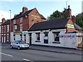
3
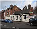
Greyhound and Two Chefs, Lichfield
Viewed across the A51 Upper St John Street in February 2018.
Business names in view are Greyhound Inn and Two Chefs Indian takeaway.
Image: © Jaggery
Taken: 17 Feb 2018
0.06 miles
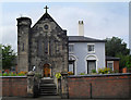
4
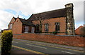
Chapel Lane side of Holy Cross Catholic church, Lichfield
The church on the corner of Upper St John Street is in the Roman Catholic Parish of Holy Cross and Saints Peter & Paul in the Archdiocese of Birmingham. The church was built in 1802-1803, enlarged and refronted in 1834. Grade II listed in 1994. https://www.geograph.org.uk/photo/5691572 to a corner view of the church.
Image: © Jaggery
Taken: 17 Feb 2018
0.06 miles
5
Lichfield - Upper St John's Street at the Greyhound Inn
Image: © Peter Whatley
Taken: 7 Dec 2011
0.06 miles
6
Holy Cross Church
Buddleia grows in the weirdest places doesn't it?
It's going to need getting off that turret before the masonry is damaged.
Image: © Des Blenkinsopp
Taken: 16 Aug 2010
0.06 miles
7
Alternative route direction sign, Upper St John Street, Lichfield
Vehicles too high for the 4.2m/14' headroom bridges 200 yards ahead can turn right into Cherry Orchard https://www.geograph.org.uk/photo/5697087 for an alternative route.
Image: © Jaggery
Taken: 17 Feb 2018
0.06 miles
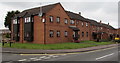
8
Upper St John Street houses, Lichfield
South of the Barnfield Close junction.
Image: © Jaggery
Taken: 17 Feb 2018
0.06 miles
9
Greyhound Inn
Greyhound Inn on Upper St John Street in Lichfield.
Image: © Philip Halling
Taken: 25 Aug 2018
0.06 miles
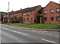
10
Brick houses, Upper St John Street, Lichfield
North of the Barnfield Close junction.
Image: © Jaggery
Taken: 17 Feb 2018
0.06 miles