IMAGES TAKEN NEAR TO
Walsall Road, LICHFIELD, WS14 0DG
Introduction
This page details the photographs taken nearby to Walsall Road, WS14 0DG by members of the Geograph project.
The Geograph project started in 2005 with the aim of publishing, organising and preserving representative images for every square kilometre of Great Britain, Ireland and the Isle of Man.

There are currently over 7.5m images from over14,400 individuals and you can help contribute to the project by visiting https://www.geograph.org.uk
Image Map
Images are licensed for reuse under creativecommons.org/licenses/by-sa/2.0
Notes
- Clicking on the map will re-center to the selected point.
- The higher the marker number, the further away the image location is from the centre of the postcode.
Image Listing (18 Images Found)
Images are licensed for reuse under creativecommons.org/licenses/by-sa/2.0
Image
Details
Distance
1
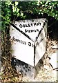
Old Milepost by the A461, Walsall Road, Hammerwich Parish
Cast iron post by the A461, in parish of HAMMERWICH (LICHFIELD District), near "Boat Inn" PH, Summerhill, on the verge, on North West side of road. Cochrane iron casting, erected by the County Council in the 20th century.
Inscription reads:-
: LICHFIELD 3½ : : OGLEY HAY / PARISH : : WALSALL / 6 :
Maker:-
: Cochrane & Co, Dudley. :
Milestone Society National ID: ST_WLLF06.
Image: © J Higgins
Taken: 1 Jan 2000
0.07 miles
2
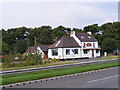
The Boat
The Pub on the A461 takes its name from standing alongside the Wyrley & Essington Canal which no longer exists in this section, but is replaced by the M6 Toll.
Image: © Gordon Griffiths
Taken: 15 Sep 2008
0.11 miles

4
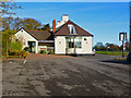
Oddfellows in the Boat
Public house/restaurant on the A461 and adjoining the disused Wyrley & Essington Canal. The emphasis is on the food but they do have a Casque Mark for the beers too.
Image: © Chris Allen
Taken: 21 Nov 2015
0.12 miles
5

Large garden, or field, belonging to houses on the A461
The adjacent plot of land to the field in Image, which appear to be part of the properties seen in Image
Image: © Richard Law
Taken: 7 Feb 2025
0.14 miles
6

SW along Boat Lane
A wintertime view of the same scene as Image
Image: © Richard Law
Taken: 7 Feb 2025
0.14 miles


9
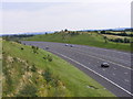
M6 Toll East
Viewed from the A461 bridge.
Image: © Gordon Griffiths
Taken: 15 Sep 2008
0.20 miles