IMAGES TAKEN NEAR TO
Christchurch Lane, LICHFIELD, WS13 8AL
Introduction
This page details the photographs taken nearby to Christchurch Lane, WS13 8AL by members of the Geograph project.
The Geograph project started in 2005 with the aim of publishing, organising and preserving representative images for every square kilometre of Great Britain, Ireland and the Isle of Man.

There are currently over 7.5m images from over14,400 individuals and you can help contribute to the project by visiting https://www.geograph.org.uk
Image Map
Images are licensed for reuse under creativecommons.org/licenses/by-sa/2.0
Notes
- Clicking on the map will re-center to the selected point.
- The higher the marker number, the further away the image location is from the centre of the postcode.
Image Listing (15 Images Found)
Images are licensed for reuse under creativecommons.org/licenses/by-sa/2.0
Image
Details
Distance
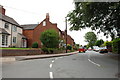
2
The Old Vicarage
Dating from the 1840s, with the later addition of a brick range to the rear, the Old Vicarage was originally built for Mrs Ellen Hinckley whose tomb lies behind the nearby church Image It was Grade II listed https://britishlistedbuildings.co.uk/101209846-easter-hill-and-the-old-vicarage-lichfield#.Yzm7FHbMLIU & https://historicengland.org.uk/listing/the-list/list-entry/1209846 in 1970. It's now divided into flats.
Image: © Richard Law
Taken: 20 Sep 2022
0.02 miles
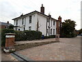
3
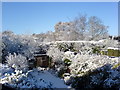
Rear window - snowy April
Leomansley Road - looking West
Image: © JonT
Taken: 6 Apr 2008
0.03 miles
4
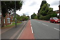
A461, Walsall Road, Lichfield
Looking from Lichfield towards Walsall. On the left is a little cul-de-sac by the name of Victoria Gardens.
Image: © Mick Malpass
Taken: 20 Jul 2011
0.15 miles
5
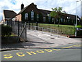
Christ Church Primary School
Founded in 1847 and located along Christ Church Lane in the Leomansley area of Lichfield.
Image: © David Rogers
Taken: 31 Jul 2010
0.17 miles
6
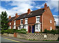
Leomansley Villas
Built in 1903 on Christ Church Lane. Note the contradictory spelling for this area of Lichfield.
Image: © David Rogers
Taken: 31 Jul 2010
0.18 miles
8
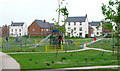
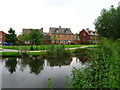
Trunkfield Playground
Beside Trunkfield Brook and close to Darwin Park.
Image: © David Rogers
Taken: 28 Jun 2009
0.20 miles
9
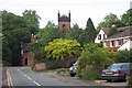
Christ Church Lane
Christ Church is visible above the trees
Image: © Geoff Pick
Taken: 25 May 2006
0.20 miles
10
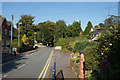
Christchurch Lane
Christ Church is mostly hidden by trees.
Image: © Bill Boaden
Taken: 20 Sep 2019
0.21 miles