IMAGES TAKEN NEAR TO
Birmingham Road, LICHFIELD, WS13 6PP
Introduction
This page details the photographs taken nearby to Birmingham Road, WS13 6PP by members of the Geograph project.
The Geograph project started in 2005 with the aim of publishing, organising and preserving representative images for every square kilometre of Great Britain, Ireland and the Isle of Man.

There are currently over 7.5m images from over14,400 individuals and you can help contribute to the project by visiting https://www.geograph.org.uk
Image Map
Images are licensed for reuse under creativecommons.org/licenses/by-sa/2.0
Notes
- Clicking on the map will re-center to the selected point.
- The higher the marker number, the further away the image location is from the centre of the postcode.
Image Listing (177 Images Found)
Images are licensed for reuse under creativecommons.org/licenses/by-sa/2.0
Image
Details
Distance
1
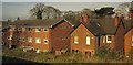
Houses at Lichfield
Backing onto the railway track; their facades face the A5127 Birmingham Road. The trees surround tennis courts beyond.
Image: © Derek Harper
Taken: 6 Apr 2012
0.00 miles
3
Bojangles in Lichfield
Bojangles dance school is set back from the west side of the A51 Upper St John Street.
Image: © Jaggery
Taken: 17 Feb 2018
0.08 miles
4
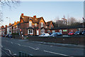
Kingfisher Club
A private members club which was formerly the Conservative Club.
Image: © Bill Boaden
Taken: 27 Dec 2017
0.08 miles
5
Wiltell Road, Lichfield
From Upper St John Street, Wiltell Road leads to Waverley Walk.
Image: © Jaggery
Taken: 17 Feb 2018
0.08 miles
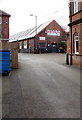
6
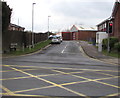
Entrance to the former Lichfield Brewery site, Lichfield
From the A51 Upper St John Street viewed in February 2018. Production at the brewery ceased in the early 1930s. The building on the left is Wiltell Lodge. https://www.geograph.org.uk/photo/6098715 The former brewery office https://www.geograph.org.uk/photo/6098721 is on the right.
Image: © Jaggery
Taken: 17 Feb 2018
0.08 miles
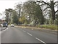
7
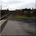
Cross City Line, Lichfield
Looking to the southwest along the Cross City Line from Lichfield City station. The route ahead is to Redditch via Birmingham New Street. The next station ahead is Shenstone (Staffordshire) on the approach to Birmingham.
Image: © Jaggery
Taken: 17 Feb 2018
0.09 miles
8
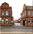
The Lichfield Brewery
An early casualty of brewery mergers, Lichfield was bought out by Samuel Allsopp's brewery in 1930.
This building was the offices, and other brewery looking buildings exist round the back still being used for this and that.
Massive brewery history website with a short section on Lichfield on
http://www.midlandspubs.co.uk/breweries/staffordshire.htm
Image: © Des Blenkinsopp
Taken: 16 Aug 2010
0.09 miles
9
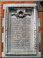
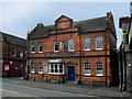
Lichfield Brewery War Memorial
On the front of the old Lichfield Brewery building Image is this WW1 memorial to brewery staff who died.
Image: © Des Blenkinsopp
Taken: 16 Aug 2010
0.09 miles
10
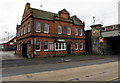
Former Lichfield Brewery office, Upper St John Street, Lichfield
Alongside the A51 near a railway bridge. The Lichfield Lore website records that the brewery company was taken over by Samuel Allsopp and Co in 1930. Production at the Lichfield Brewery ceased soon afterwards. In 1931, the Lichfield Aerated Water Co set up at the site, but were taken over by a Derby company, Burrows & Sturgess (who produced soft drinks and who claimed to have produced the first Iron Bru). A new company called the Birmingham Chemical Co was established from this takeover. It appears that the site became known as the Wiltell Works from this company's slogan Quality Will Tell. Wiltell Road https://www.geograph.org.uk/photo/5691692 is nearby.
Image: © Jaggery
Taken: 17 Feb 2018
0.09 miles