IMAGES TAKEN NEAR TO
Birmingham Road, WALSALL, WS1 2NH
Introduction
This page details the photographs taken nearby to Birmingham Road, WS1 2NH by members of the Geograph project.
The Geograph project started in 2005 with the aim of publishing, organising and preserving representative images for every square kilometre of Great Britain, Ireland and the Isle of Man.

There are currently over 7.5m images from over14,400 individuals and you can help contribute to the project by visiting https://www.geograph.org.uk
Image Map
Images are licensed for reuse under creativecommons.org/licenses/by-sa/2.0
Notes
- Clicking on the map will re-center to the selected point.
- The higher the marker number, the further away the image location is from the centre of the postcode.
Image Listing (29 Images Found)
Images are licensed for reuse under creativecommons.org/licenses/by-sa/2.0
Image
Details
Distance
1
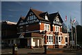
The County Hotel
The County Hotel, which is situated on the Birmingham Road close to Six Ways, Walsall, is one of the towns busier hotels.
Image: © Derek Bennett
Taken: 10 Feb 2008
0.04 miles
2
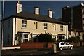
Houses at Six Ways
Six ways is a busy junction on the main road from Walsall to Birmingham. Despite the building of some ugly 1960's blocks of flats, there are still some nice old properties such as this in the area.
Image: © Derek Bennett
Taken: 10 Feb 2008
0.09 miles
3
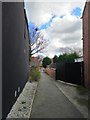
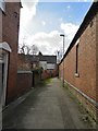
Short alleyway between Emery Street and Jesson Road, Walsall
Image: © Frank Smith
Taken: 11 Mar 2019
0.09 miles
4
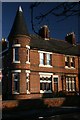
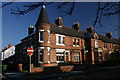
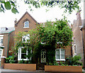
House with turret
This corner house was built with a wonderful turret.
Image: © Derek Bennett
Taken: 3 Dec 2008
0.10 miles
5
House with turret
This is a grand old property, I have always admired that turret.
Image: © Derek Bennett
Taken: 2 Dec 2008
0.10 miles
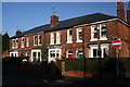
7
Houses on the Sutton Road
Fine old houses on the Sutton Road, Walsall.
Image: © Derek Bennett
Taken: 2 Dec 2008
0.12 miles
8
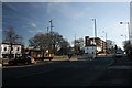
Six Ways Roundabout
Six Ways Walsall, looking towards the Sutton and Birmingham Roads from Birmingham Street.
Image: © Derek Bennett
Taken: 10 Feb 2008
0.16 miles
9
Short alley between Sandymount Road and Belvidere Road, Walsall
The now defunct Highgate Brewery is behind the wall on the right.
Image: © Frank Smith
Taken: 11 Mar 2019
0.16 miles
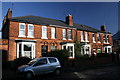
10
Housing in Sutton Road, Walsall
Early twentieth century houses of considerable size were built in Sutton Road opposite Queen Mary's Grammar and Mayfield Preparatory Schools. Even by the mid 1960s, some of these had been converted into flats (three in this instance), which were rented out. These have now been sold as separate dwellings.
Image: © Roger D Kidd
Taken: 29 Jul 2011
0.16 miles