IMAGES TAKEN NEAR TO
Eyland Grove, WALSALL, WS1 2AL
Introduction
This page details the photographs taken nearby to Eyland Grove, WS1 2AL by members of the Geograph project.
The Geograph project started in 2005 with the aim of publishing, organising and preserving representative images for every square kilometre of Great Britain, Ireland and the Isle of Man.

There are currently over 7.5m images from over14,400 individuals and you can help contribute to the project by visiting https://www.geograph.org.uk
Image Map
Images are licensed for reuse under creativecommons.org/licenses/by-sa/2.0
Notes
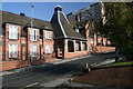
- Clicking on the map will re-center to the selected point.
- The higher the marker number, the further away the image location is from the centre of the postcode.
Image Listing (151 Images Found)
Images are licensed for reuse under creativecommons.org/licenses/by-sa/2.0
Image
Details
Distance
1
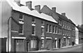
Lower Rushall Street in Walsall, Staffordshire
The approximate date for this image is circa 1968-1973, being scanned from a monochrome negative. The far wall includes the words: BUCKLES AND BELT CLASPS, LEATHER GOODS AND CLOTHING TRADES,BRACE FITTINGS, IRON AND BRASS FOUNDERS.
The premises is the Eyland and Sons Ltd, Buckle Manufacturers, Rushall Street Works, but they were originally far more than that.
"... Moses Eyland, who was making spectacles in Lower Rushall Street by 1813; by 1818 he combined the trade with that of saddler's ironmonger. By 1822 the firm had become Moses Eyland and Sons. By 1834 it was grinding lenses and producing some 3,000 pairs of spectacles a week. In 1889 it was grinding glass and rock-crystal lenses for its spectacles on a large scale as well as making buckles and engaging in gilding and electro-plating. Tariff barriers killed the export trade in spectacles, and early in the 20th century Eylands abandoned glass-working." (from A History of the County of Stafford: Volume 17: ) ed. M W Greenslade)
Image: © Roger D Kidd
Taken: 1 Jan 1972
0.03 miles
2
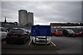
Intown Row - Walsall, West Midlands
A view of the Intown Row car park in Walsall. Intown Row is partnered by another adjoining street, this one being just 'Intown'. In all my years this is the first time I have met with such names. Time photo taken 2.08 pm GMT (Greenwich Mean Time).
Image: © Martin Richard Phelan
Taken: 29 Jan 2020
0.06 miles
3
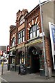
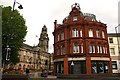
Flan O'Briens on Upper Rushall Street
Flan O'Briens is an Irish Bar on the corner of Upper Rushall Street and Ablewell Street.
Image: © Steve Daniels
Taken: 14 Jul 2014
0.07 miles
4
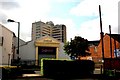
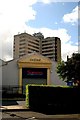
Casino & Tamebridge Tower
This grim looking casino close to Walsall town centre is overlooked by the even grimmer Tamebridge Tower office block. It was from the top of there I took some of my other Geograph images overlooking Walsall and St Matthews Church.
Image: © Derek Bennett
Taken: 24 Aug 2008
0.07 miles
5
Sorrento it ain't
This casino close to the town centre of Walsall has been named 'Sorrento'. I've been to Sorrento in Italy six times and it's a great deal more pleasant than this.
Image: © Derek Bennett
Taken: 24 Aug 2008
0.08 miles
6
Building with Staffordshire knot
This unused building, which proudly carries the Staffordshire knot on its facade, was obviously built in the days when Walsall was part of Staffordshire, not the artificial and meaningless construct created in the 1970's now called the 'West Midlands'.
Mark Powell adds, "Former drill hall of the 5th battalion South Staffordshire Regiment Territorial Army. Later a night club called the fifth."
Image: © Derek Bennett
Taken: 3 Aug 2008
0.08 miles
7
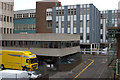
Freer Street, Walsall
Viewed from level 5 of the Freer Street multi-storey car park with Tameway Tower on the left.
Image: © Mark Anderson
Taken: 5 Jul 2012
0.10 miles
8
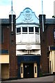
Building Society and Town Hall
This lovely old curved building in Walsall town centre was once a bank and is now a Cheltenham & Gloucester building society. Walsall Town Hall is situated to the left in the background.
Image: © Derek Bennett
Taken: 24 Aug 2008
0.11 miles
9
Sheltered Accommodation in Tantara Street
This was an old school building and is now sheltered accommodation.
Image: © Derek Bennett
Taken: 12 Oct 2008
0.11 miles
10
Left turn off Lichfield Street - Walsall, West Midlands
Here is a view south-west along Lichfield Street in Walsall. With it comes a street name - Intown - that I have never in all my years ever seen before. To the north lies Intown Row which at its north-west end also joins Lichfield Street. On the right of the photo is the Town Hall. Time photo taken 1.45 pm GMT (Greenwich Mean Time).
Image: © Martin Richard Phelan
Taken: 29 Jan 2020
0.11 miles