IMAGES TAKEN NEAR TO
Braemar Gardens, CANNOCK, WS12 4LS
Introduction
This page details the photographs taken nearby to Braemar Gardens, WS12 4LS by members of the Geograph project.
The Geograph project started in 2005 with the aim of publishing, organising and preserving representative images for every square kilometre of Great Britain, Ireland and the Isle of Man.

There are currently over 7.5m images from over14,400 individuals and you can help contribute to the project by visiting https://www.geograph.org.uk
Image Map
Images are licensed for reuse under creativecommons.org/licenses/by-sa/2.0
Notes
- Clicking on the map will re-center to the selected point.
- The higher the marker number, the further away the image location is from the centre of the postcode.
Image Listing (8 Images Found)
Images are licensed for reuse under creativecommons.org/licenses/by-sa/2.0
Image
Details
Distance
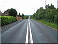
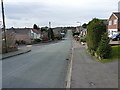
1
Down Thornhill Road
Looking down this main feeder into the housing estate, with Kenmore Avenue and Image leading off to the left/north.
Image: © Richard Law
Taken: 22 Feb 2014
0.04 miles
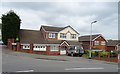
2
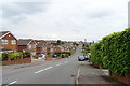
Thornhill Road, Hednesford
Looking south east.
Image: © JThomas
Taken: 18 May 2019
0.05 miles
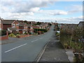
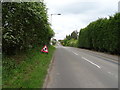
4
Up Thornhill Road
One of the main feeder roads into the Pye Green housing estate.
Image: © Richard Law
Taken: 22 Feb 2014
0.07 miles
6
Pye Green Road, Hednesford
Looking north east.
Image: © JThomas
Taken: 18 May 2019
0.09 miles
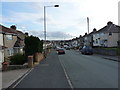
7
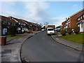
Linwood Drive, Pye Green
Part of the extensive Pye Green housing estate.
Image: © Richard Law
Taken: 22 Feb 2014
0.11 miles