IMAGES TAKEN NEAR TO
The Green, CANNOCK, WS11 1UE
Introduction
This page details the photographs taken nearby to The Green, WS11 1UE by members of the Geograph project.
The Geograph project started in 2005 with the aim of publishing, organising and preserving representative images for every square kilometre of Great Britain, Ireland and the Isle of Man.

There are currently over 7.5m images from over14,400 individuals and you can help contribute to the project by visiting https://www.geograph.org.uk
Image Map
Images are licensed for reuse under creativecommons.org/licenses/by-sa/2.0
Notes
- Clicking on the map will re-center to the selected point.
- The higher the marker number, the further away the image location is from the centre of the postcode.
Image Listing (52 Images Found)
Images are licensed for reuse under creativecommons.org/licenses/by-sa/2.0
Image
Details
Distance
1
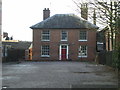
Former chapel manse, Cannock
Built around 1824 (the date is ascribed to the adjacent Image) as a manse house, and Grade II listed https://britishlistedbuildings.co.uk/101248967-manse-immediately-south-of-congregational-chapel-cannock-chase#.XkOq5zH7RPY & https://historicengland.org.uk/listing/the-list/list-entry/1248967 in 1995. The interior apparently retains many original features of timberwork and plaster.
Image: © Richard Law
Taken: 8 Feb 2020
0.02 miles
3
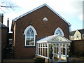
The old Congregational Chapel
Erected in 1824 according to the plaque in the gable wall above the original doorway, and now converted to a cafe/bar/coffee-shop called Holy Smoke (very clever, that). The interior retains the gallery, the pulpit, albeit moved to one corner, and has a large musical organ beside the bar. It was Grade II listed https://britishlistedbuildings.co.uk/101248947-congregational-chapel-cannock-chase#.XkBFNmj7Tcs & https://historicengland.org.uk/listing/the-list/list-entry/1248947 in 1995.
Image: © Richard Law
Taken: 8 Feb 2020
0.03 miles
4
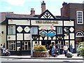
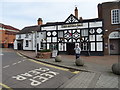
The Royal Oak, Cannock
Town Centre Pub in Market Street
Image: © Geoff Pick
Taken: 14 Jun 2008
0.03 miles
5
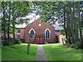
Cannock United Reformed Church
The church, which dates form 1865, was finally closed in November 2009.
The congregation had moved away from the church’s town centre site. Lack of car parking and modern facilities also contributed.
Image: © Geoff Pick
Taken: 31 Jul 2010
0.03 miles
6
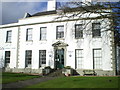
Former Council Offices
Built in the mid 18th century, and now known as The White House (very imaginatively) and formerly as The Sanctuary; a brief history is described at Image In the early 1970s, it was the offices of the local council, and at that time attracted a Grade II* listing https://britishlistedbuildings.co.uk/101060217-council-house-cannock-chase#.XkOpbTH7RPY & https://historicengland.org.uk/listing/the-list/list-entry/1060217.
Image: © Richard Law
Taken: 8 Feb 2020
0.04 miles
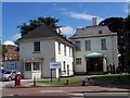
8
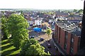
View of Cannock from top of St. Luke's Church Tower
Image: © Geoff Pick
Taken: 31 May 2006
0.04 miles
9

The White House (or The Sanctuary)
Georgian House (2* Listed) built for Sir Robert Fisher in 1783, later a girls school, Council Offices from 1928 and Technical College from 1980s. The college moved out in 2016 and local developer Fred Prichard has converted it to offices for his company, a beauty salon, restaurant, offices and eight flats.
Image: © John M
Taken: 14 Mar 2018
0.05 miles