IMAGES TAKEN NEAR TO
Forge Road, WEDNESBURY, WS10 8QU
Introduction
This page details the photographs taken nearby to Forge Road, WS10 8QU by members of the Geograph project.
The Geograph project started in 2005 with the aim of publishing, organising and preserving representative images for every square kilometre of Great Britain, Ireland and the Isle of Man.

There are currently over 7.5m images from over14,400 individuals and you can help contribute to the project by visiting https://www.geograph.org.uk
Image Map
Images are licensed for reuse under creativecommons.org/licenses/by-sa/2.0
Notes
- Clicking on the map will re-center to the selected point.
- The higher the marker number, the further away the image location is from the centre of the postcode.
Image Listing (7 Images Found)
Images are licensed for reuse under creativecommons.org/licenses/by-sa/2.0
Image
Details
Distance
1
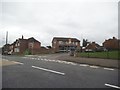
Heathfield Lane
The view from Wolverhampton Street in Darlaston.
Image: © Gordon Griffiths
Taken: 27 Sep 2016
0.11 miles
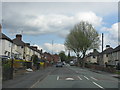
3
Darlaston - Wolverhampton Street
Stafford Street forks off to the left in the middle distance.
Image: © Peter Whatley
Taken: 11 May 2010
0.14 miles
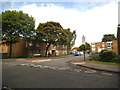
4
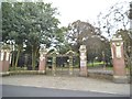
Park Gates
The view of Darlaston's George Rose Park entrance, off Wolverhampton Street.
Image: © Gordon Griffiths
Taken: 27 Sep 2016
0.16 miles
5
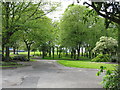
Darlaston - George Rose Park
Photographed through the very firmly locked gates.
Image: © Peter Whatley
Taken: 11 May 2010
0.18 miles
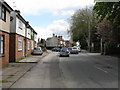
6
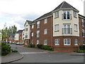
Darlaston - new apartments off Hall Street
Image: © Peter Whatley
Taken: 11 May 2010
0.21 miles
7
Whitehouse Avenue
The view off Wolverhampton Street, Darlaston.
Image: © Gordon Griffiths
Taken: 22 May 2014
0.25 miles