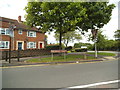
IMAGES TAKEN NEAR TO
Hampton Place, WEDNESBURY, WS10 8PG
Introduction
This page details the photographs taken nearby to Hampton Place, WS10 8PG by members of the Geograph project.
The Geograph project started in 2005 with the aim of publishing, organising and preserving representative images for every square kilometre of Great Britain, Ireland and the Isle of Man.

There are currently over 7.5m images from over14,400 individuals and you can help contribute to the project by visiting https://www.geograph.org.uk
Image Map
Images are licensed for reuse under creativecommons.org/licenses/by-sa/2.0
Notes
- Clicking on the map will re-center to the selected point.
- The higher the marker number, the further away the image location is from the centre of the postcode.
Image Listing (28 Images Found)
Images are licensed for reuse under creativecommons.org/licenses/by-sa/2.0
Image
Details
Distance
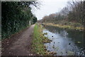
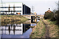
2
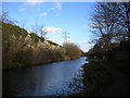
Walsall Canal, Rough Hay (1)
Approaching Midland Road Bridge.
Image: © Richard Vince
Taken: 1 Feb 2020
0.08 miles
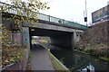
4
Midland Road Bridge, Walsall Canal, Rough Hay
Image: © Richard Vince
Taken: 1 Feb 2020
0.09 miles
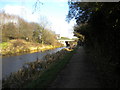
5
Willenhall Street
The view of the junction with Midland Road, Darlaston.
Image: © Gordon Griffiths
Taken: 22 May 2014
0.09 miles
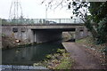
6
Bridge carrying Midland Road over Walsall Canal, 1979
A map from the website of the Canal and River Trust has the bridge named as Longbridge Bridge; it appears to be little changed in the 41 years since the image was recorded as can be seen in Richard Vince's image from 2020 - https://www.geograph.org.uk/photo/6392747.
A significant change however has taken place beyond the bridge; the rather new-looking factory unit in this image has gone, cleared no doubt to allow the building of the A463, 'Black Country Route' dual carriageway.
Image: © Trevor Littlewood
Taken: 16 Apr 1979
0.09 miles
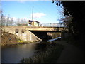
9
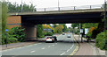
Bridge over the A462 in Willenhall, Walsall
The bridge carries the Black Country Route A454, an effective by-pass route through this industrial and residential area, begun in the 1980s and fully opened by 1995. Beyond the bridge, Owen Road becomes Midland Road.
Image: © Roger D Kidd
Taken: 18 Oct 2013
0.12 miles
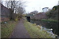
10
Walsall Canal, Rough Hay (2)
East of Midland Road Bridge.
Image: © Richard Vince
Taken: 1 Feb 2020
0.12 miles