IMAGES TAKEN NEAR TO
Meadow Road, DROITWICH, WR9 9BZ
Introduction
This page details the photographs taken nearby to Meadow Road, WR9 9BZ by members of the Geograph project.
The Geograph project started in 2005 with the aim of publishing, organising and preserving representative images for every square kilometre of Great Britain, Ireland and the Isle of Man.

There are currently over 7.5m images from over14,400 individuals and you can help contribute to the project by visiting https://www.geograph.org.uk
Image Map
Images are licensed for reuse under creativecommons.org/licenses/by-sa/2.0
Notes
- Clicking on the map will re-center to the selected point.
- The higher the marker number, the further away the image location is from the centre of the postcode.
Image Listing (50 Images Found)
Images are licensed for reuse under creativecommons.org/licenses/by-sa/2.0
Image
Details
Distance
1
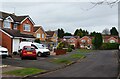
End of Park Way, Droitwich Spa, Worcs
Park Way, a long residential road, ends here as a cul-de-sac.
Image: © P L Chadwick
Taken: 5 Feb 2022
0.05 miles
2
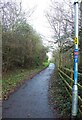
Footpath and cycleway leading to Meadow Road, Droitwich Spa, Worcs
This footpath and cycleway leads from the entrance to the tunnel under Roman Way (part of the A38 road) to Meadow Road. The cycleway is part of National Cycleway route 45 and around here follows a different route to that shown on some maps.
Image
Image: © P L Chadwick
Taken: 9 Jan 2022
0.06 miles
3
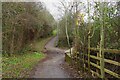
Meeting of paths at entrance to tunnel under A38 road, Droitwich Spa, Worcs
Paths from Park Way and Meadow Road meet at the entrance to the tunnel under the A38 road (Roman Way). On the other side of the tunnel is the King George V Playing Field.
Image
Image: © P L Chadwick
Taken: 5 Feb 2022
0.06 miles
4

Tunnel under Roman Way (A38), Droitwich Spa, Worcs
The tunnel passes under the dual carriageways of the A38 road. It is shared by a public footpath and National Cycleway Route 45. When these emerge at the other end of the tunnel the route splits. One arm goes to Park Way, and the other to Meadow Road.
Image
Image: © P L Chadwick
Taken: 9 Jan 2022
0.07 miles
5
Footpath to Park Way, Droitwich Spa, Worcs
This footpath leads from the entrance to the tunnel under Roman Way (part of the A38 road) up to the residential area of Park Way and adjacent roads.
Image
Image: © P L Chadwick
Taken: 9 Jan 2022
0.08 miles
6
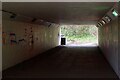
Interior view of tunnel under Roman Way (A38 road), Droitwich Spa, Worcs
The tunnel takes a footpath and cycleway under Roman Way, which is part of the A38 road.
Image: © P L Chadwick
Taken: 5 Feb 2022
0.08 miles
7

Tunnel under Roman Way (A38), Droitwich Spa, Worcs
The tunnel takes a public footpath and National Cycleway Route 45 under the dual carriageways of Roman Way (part of the A38 road). At the other end of the tunnel, the footpath and cycleway cross the River Salwarpe by a bridge and then enter the King George V Playing Fields.
Image
Image: © P L Chadwick
Taken: 9 Jan 2022
0.08 miles
8
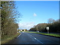
A38 Roman Way Droitwich Spa Approaching Island With A442
Image: © Roy Hughes
Taken: 9 Feb 2018
0.08 miles
9

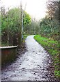
Bridge leading to tunnel under A38 road, Droitwich Spa, Worcs
The bridge crosses the River Salwarpe and carries a public footpath and National Cycleway route 45. These then enter a tunnel which takes them under the dual carriageway A38 (Roman Way). On the other side the footpath divides into two, one arm leading to Park Way, and the other to Meadow Road.
Image: © P L Chadwick
Taken: 9 Jan 2022
0.09 miles
10
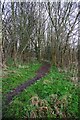
Public footpath to Kidderminster Road, Droitwich Spa, Worcs
This footpath commences near the entrance to the tunnel under Roman Way (A38) from the King George V Playing Field. It goes through woodland and eventually passes along one side of an Aldi supermarket and comes out on Kidderminster Road.
Image: © P L Chadwick
Taken: 9 Jan 2022
0.09 miles