IMAGES TAKEN NEAR TO
Chawson Pleck, DROITWICH, WR9 8TB
Introduction
This page details the photographs taken nearby to Chawson Pleck, WR9 8TB by members of the Geograph project.
The Geograph project started in 2005 with the aim of publishing, organising and preserving representative images for every square kilometre of Great Britain, Ireland and the Isle of Man.

There are currently over 7.5m images from over14,400 individuals and you can help contribute to the project by visiting https://www.geograph.org.uk
Image Map
Images are licensed for reuse under creativecommons.org/licenses/by-sa/2.0
Notes
- Clicking on the map will re-center to the selected point.
- The higher the marker number, the further away the image location is from the centre of the postcode.
Image Listing (38 Images Found)
Images are licensed for reuse under creativecommons.org/licenses/by-sa/2.0
Image
Details
Distance
1
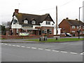
The Doverdale Arms Public House
A sturdy pub in one of the older parts of Droitwich Spa. Situated at the corner of Stalls Farm Road and Old Coach Road.
Image: © Peter Whatley
Taken: 23 Mar 2010
0.07 miles
2

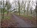
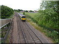
Railway southwest of Droitwich Spa railway station
Towards a footbridge about 550 metres from the camera. The next station ahead is Worcester Foregate Street.
Image: © Jaggery
Taken: 16 Nov 2016
0.08 miles
5
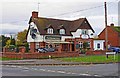
The Doverdale Arms, Stalls Farm Road, Droitwich Spa
Located on the corner of Stalls Farm Road and Old Coach Road in the area of the town known as Chawson. The pub has a beer garden and function room, and a large car park accessed from Old Coach Road. The pub is often referred to locally as the Dovey.
Image: © P L Chadwick
Taken: 3 Nov 2012
0.08 miles
6
Train passing under footbridge at Packington Crossing
Droitwich Spa, Worcestershire
Image: © Jeff Gogarty
Taken: 8 Jul 2015
0.09 miles
7
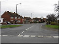
Stalls Farm Road, Droitwich Spa
Most of the housing around here was originally council housing built by the former Droitwich Borough Council in the 1945-1950 period. Photographed from Old Coach Road.
Image: © P L Chadwick
Taken: 3 Nov 2012
0.09 miles
8
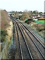
Footbridge View
Looking along the railway line towards the station at Droitwich Spa from a footbridge on a chilly December morning.
Image: © Mary and Angus Hogg
Taken: 6 Dec 2012
0.10 miles
9
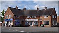
Parade of shops, Stalls Farm Road, Droitwich Spa, Worcs
From left to right are Lakhy News & Off Licence, Mobility Limited, and Lulu's (hairdresser).
Image: © P L Chadwick
Taken: 16 Aug 2015
0.13 miles
10
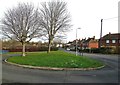
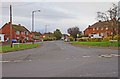
Steynors Avenue, Droitwich Spa
A turning space on Steynors Avenue in this residential area of Droitwich Spa.
Image: © Mary and Angus Hogg
Taken: 6 Dec 2012
0.13 miles