IMAGES TAKEN NEAR TO
Charles Henry Road, DROITWICH, WR9 8QQ
Introduction
This page details the photographs taken nearby to Charles Henry Road, WR9 8QQ by members of the Geograph project.
The Geograph project started in 2005 with the aim of publishing, organising and preserving representative images for every square kilometre of Great Britain, Ireland and the Isle of Man.

There are currently over 7.5m images from over14,400 individuals and you can help contribute to the project by visiting https://www.geograph.org.uk
Image Map
Images are licensed for reuse under creativecommons.org/licenses/by-sa/2.0
Notes
- Clicking on the map will re-center to the selected point.
- The higher the marker number, the further away the image location is from the centre of the postcode.
Image Listing (190 Images Found)
Images are licensed for reuse under creativecommons.org/licenses/by-sa/2.0
Image
Details
Distance
1
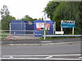
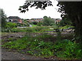
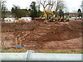
Site offices for canal restoration
I hadn't been this way for a few weeks and was surprised to see that work had finally started on re-instating this section of the Droitwich Junction Canal. This is being undertaken by contractors with lots of kit and on-site security. The lock between the canal and the River Salwarpe will be very close to the site offices. I must try to keep an eye on this.
Image: © Chris Allen
Taken: 20 Jul 2008
0.12 miles
2
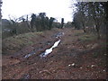
Droitwich Narrow Canal restoration
Initial site clearance work has started on the restoration of this length of the canal into Droitwich. Tree clearance has taken place now so as to avoid disturbance to nesting creatures later in the year. Construction work is due to commence in mid 2007.
Image: © David Stowell
Taken: 1 Jan 2007
0.12 miles
3
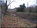
Droitwich Narrow Canal restoration
Initial site clearance work has started on the restoration of this length of the canal into Droitwich. Tree clearance has taken place now so as to avoid disturbance to nesting creatures later in the year. The canal originally continued to the left in to Droitwich parallel to the River Salwarpe. The restoration will see a lock constructed at this point and the canal will go into the River Salwarpe to pass under the bridge just visible behind the car in the picture and avoid buildings constructed on the old canal alignment.
Image: © David Stowell
Taken: 1 Jan 2007
0.12 miles
4
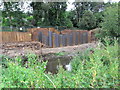
Droitwich Junction Canal restoration
The River Salwarpe is in the foreground and the sheet piling is part of the new canal. This must be very close to the new lock in to the Salwarpe. There will be a short stretch of navigable river between the two canals. The original lock is under a building and the chamber can still be entered.
Image: © Chris Allen
Taken: 3 Aug 2008
0.12 miles
5
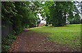
Grassed area by footpath from Hanbury Road, Droitwich Spa
The footpath continues on the left and eventually leads to a modern housing estate, coming out on Mayflower Road.
Image
Image: © P L Chadwick
Taken: 2 Jul 2011
0.12 miles
6
Droitwich Junction Canal - the bywash weir
The structure in the foreground was long a mystery to me but Peter Lee's website - http://www.leepd60.110mb.com/ - has explained all. This is the bywash weir that supplies water to a long pipeline that connects the Junction Canal to the Barge Canal and bypasses the canalised section of the River Salwarpe. This apparently preserves water quality in the Salwarpe. Immediately next to the weir is the newly formed cut and there is a mooring wharf to the left of the weir. In the left background with bright orange netting is the nearly completed lock No. 7.
Image: © Chris Allen
Taken: 31 Jan 2009
0.13 miles
7
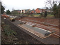
Droitwich Junction Canal
Lock No. 7 - the bottom gates are in. Although the chamber is in water, the cut only just extends left out of picture and there is still no final connection to the Salwarpe - a nearly finished canal but going nowhere yet.
Image: © Chris Allen
Taken: 14 Mar 2009
0.13 miles
8
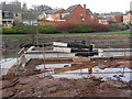
One day soon!
- There will be the connection between the Droitwich Junction Canal and the river Salwarpe. Lock No. 7 is all finished with nowhere to go. There is currently an overflow back into the river but eventually the river will be canalised and the lock will lead into it.
Image: © Chris Allen
Taken: 4 Aug 2009
0.13 miles
9
The canalisation of the River Salwarpe
The earth bank in to the river allows access for the heavy plant. The pipe in the foreground is taking the river around the dewatered section. The two white boxes are mobile generators providing power for the pumps.
Image: © Chris Allen
Taken: 6 Feb 2011
0.13 miles
10
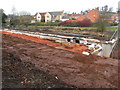
Droitwich Junction Canal - lock No. 7
This is nearly finished and the top gate is lying loose in the chamber. The blue brick capping is largely laid and the cut to the right has been completed to profile. I moved to Droitwich in the late 1970s and the restoration of the canal has been in the planning since at least then.
Image: © Chris Allen
Taken: 31 Jan 2009
0.13 miles