IMAGES TAKEN NEAR TO
Rose Avenue, DROITWICH, WR9 8QE
Introduction
This page details the photographs taken nearby to Rose Avenue, WR9 8QE by members of the Geograph project.
The Geograph project started in 2005 with the aim of publishing, organising and preserving representative images for every square kilometre of Great Britain, Ireland and the Isle of Man.

There are currently over 7.5m images from over14,400 individuals and you can help contribute to the project by visiting https://www.geograph.org.uk
Image Map
Images are licensed for reuse under creativecommons.org/licenses/by-sa/2.0
Notes
- Clicking on the map will re-center to the selected point.
- The higher the marker number, the further away the image location is from the centre of the postcode.
Image Listing (196 Images Found)
Images are licensed for reuse under creativecommons.org/licenses/by-sa/2.0
Image
Details
Distance
1
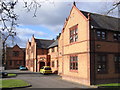
The former St John's Hospital, Droitwich
Now a nursing home and originally a workhouse. For many years it was the annexe to the Highfields Hospital - a tertiary referral centre for rheumatology patients from around the country. Two hospitals have retrenched to a handful of beds in the Highfield Unit at Worcestershire Royal Hospital.
Image: © Chris Allen
Taken: 22 Feb 2009
0.14 miles
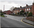
2
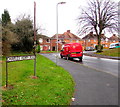
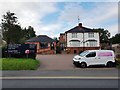
Charles Henry Road, Droitwich
The northwest end of Charles Henry Road, at the junction with The Holloway.
Charles Henry Road extends for 400 metres from here to Winslow Avenue.
The red Royal Mail Fiat Doblo van has the identifier D3.
Image: © Jaggery
Taken: 16 Nov 2016
0.15 miles
3
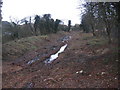
Droitwich Narrow Canal restoration
Initial site clearance work has started on the restoration of this length of the canal into Droitwich. Tree clearance has taken place now so as to avoid disturbance to nesting creatures later in the year. Construction work is due to commence in mid 2007.
Image: © David Stowell
Taken: 1 Jan 2007
0.16 miles
4
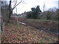
Droitwich Narrow Canal restoration
Initial site clearance work has started on the restoration of this length of the canal into Droitwich. Tree clearance has taken place now so as to avoid disturbance to nesting creatures later in the year. The canal originally continued to the left in to Droitwich parallel to the River Salwarpe. The restoration will see a lock constructed at this point and the canal will go into the River Salwarpe to pass under the bridge just visible behind the car in the picture and avoid buildings constructed on the old canal alignment.
Image: © David Stowell
Taken: 1 Jan 2007
0.16 miles
5
Row of houses, St Peter's Walk, Droitwich
Viewed across the road named The Holloway.
Image: © Jaggery
Taken: 16 Nov 2016
0.16 miles
6
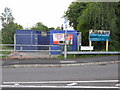
Site offices for canal restoration
I hadn't been this way for a few weeks and was surprised to see that work had finally started on re-instating this section of the Droitwich Junction Canal. This is being undertaken by contractors with lots of kit and on-site security. The lock between the canal and the River Salwarpe will be very close to the site offices. I must try to keep an eye on this.
Image: © Chris Allen
Taken: 20 Jul 2008
0.16 miles
7
Corbett Veterinery Clinic, 36 Hanbury Road, Droitwich
The clinic is operated by the practice of MacArthur Barstow & Gibbs, which has evolved from a practice set up by Frank Moody in Corbett Avenue in Droitwich in 1956.
Image: © P L Chadwick
Taken: 2 Jul 2011
0.17 miles
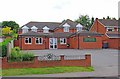
8
Scout Hall, Mayflower Road, Droitwich Spa, Worcs
This hall is used by the 3rd Droitwich (St. Peter's) Scout Group. The building is located on the corner of Mayflower Road and Cockshute Hill.
Image: © P L Chadwick
Taken: 6 Oct 2013
0.17 miles
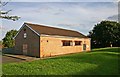
9
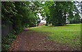
Grassed area by footpath from Hanbury Road, Droitwich Spa
The footpath continues on the left and eventually leads to a modern housing estate, coming out on Mayflower Road.
Image
Image: © P L Chadwick
Taken: 2 Jul 2011
0.17 miles
10
Handy florists for the funeral
Crump's family business on Hanbury Road, Droitwich.
Image: © Jeff Gogarty
Taken: 23 Aug 2020
0.17 miles