
IMAGES TAKEN NEAR TO
Hanbury Road, DROITWICH, WR9 8GB
Introduction
This page details the photographs taken nearby to Hanbury Road, WR9 8GB by members of the Geograph project.
The Geograph project started in 2005 with the aim of publishing, organising and preserving representative images for every square kilometre of Great Britain, Ireland and the Isle of Man.

There are currently over 7.5m images from over14,400 individuals and you can help contribute to the project by visiting https://www.geograph.org.uk
Image Map
Images are licensed for reuse under creativecommons.org/licenses/by-sa/2.0
Notes
- Clicking on the map will re-center to the selected point.
- The higher the marker number, the further away the image location is from the centre of the postcode.
Image Listing (250 Images Found)
Images are licensed for reuse under creativecommons.org/licenses/by-sa/2.0
Image
Details
Distance
1
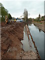
The canalisation of the River Salwarpe
This section is nearly complete. In the distance there is a shallow stretch to be dredged but the foreground and middle distance of the river appears to be full depth. The towpath is being constructed in the left hand bank and contains the bywash pipeline that connects the two canals around the river section. The left bank is formed by sheet piling but the right bank is a profiled earth embankment.
Image: © Chris Allen
Taken: 1 Apr 2011
0.00 miles
2
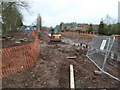
Canalisation of the River Salwarpe
Building works are in full flow between Swan Drive bridge and the town. There is still some work to do here and I wonder if a bypass around cofferdams will be installed to dewater the river bed (as has just been completed upstream).
Image: © Chris Allen
Taken: 20 Feb 2011
0.01 miles
3
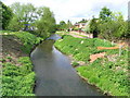
River Salwarpe
This stretch of river is to be canalised to provide the link between the Droitwich Junction Canal and the Droitwich Barge Canal.
Image: © Chris Allen
Taken: 25 Apr 2009
0.01 miles
4
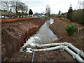
The canalisation of the River Salwarpe.
This shows the water being returned from upstream of the dewatered section. The line of the left bank of the canalised section is now clearly demarcated by sheet piling. There is an earth cofferdam in the foreground.
Image: © Chris Allen
Taken: 6 Feb 2011
0.01 miles
5
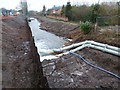
River Salwarpe, canalisation works.
This stretch is being canalised. at the bottom of the picture is the downstream earth cofferdam with the bypassed water being discharged into the River. There is sheet piling on the left. Dodderhill Church is seen in the middle background.
Image: © Chris Allen
Taken: 22 Jan 2011
0.01 miles
6
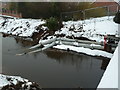
Droitwich Junction Canal Works
It would appear that a segment of the River Salwarpe is to be drained and the river flow pumped round to a point downstream. This is the discharge end of the bypass by Swan Drive bridge. This was not running when seen.
Image: © Chris Allen
Taken: 28 Dec 2010
0.02 miles
7
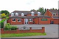
Corbett Veterinery Clinic, 36 Hanbury Road, Droitwich
The clinic is operated by the practice of MacArthur Barstow & Gibbs, which has evolved from a practice set up by Frank Moody in Corbett Avenue in Droitwich in 1956.
Image: © P L Chadwick
Taken: 2 Jul 2011
0.02 miles

9

River Salwarpe in Droitwich Spa, Worcestershire
Looking west, downstream.
Here the River Salwarpe is canalised and acts as part of the Droitwich Junction Canal. New housing development on the left is by the B4090 Saltway.
Image: © Roger Kidd
Taken: 22 Jun 2013
0.03 miles
10
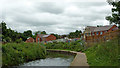
River Salwarpe in Droitwich Spa, Worcestershire
Here the River Salwarpe is canalised and acts as part of the Droitwich Junction Canal. New housing on the right is by the B4090 Saltway.
Image: © Roger Kidd
Taken: 22 Jun 2013
0.04 miles